Floods
Filters

Data from a NASA campaign in Panama and Peru will help communities prepare for tropical floods in cloud-covered areas, improve…

Spring melt along Alaska’s Kuskokwim River caused ice jams and flooding.

Above-normal precipitation has swollen rivers and damaged infrastructure statewide.

Back-to-back subtropical cyclones in March fueled destructive flash flooding on several of the Hawaiian Islands.

Villages and farmland were swamped after unusually heavy early-February rains pushed the Sinú River over its banks.

Widespread flooding affected tens of thousands of people after cyclones Fytia and Gezani drenched the island.

Weeks of intense rain overwhelmed rivers and reservoirs, displacing hundreds of thousands of people.

A rare tropical cyclone dropped torrential rains on the Indonesian island, fueling extensive and destructive floods.
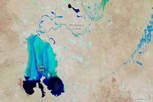
Another major tributary reached the Australian outback lake in 2025, extending the months-long flood of the vast, ephemeral inland sea.