![Request for Information – Potential [Placeholder for Prize]](https://assets.science.nasa.gov/dynamicimage/assets/science/psd/solar/2023/09/s/solarsystem_0.jpg?w=1024)


Integrated Modeling
Virtual Institute
A framework for NASA's state-of-the-art Earth system models to advance Earth understanding and deliver actionable insights for societal benefit


Integrated Modeling Virtual Institute
NASA's state-of-the-art models merge trusted observations and advanced computing power to simulate complex interactions between Earth processes and unlock new understanding of how our planet functions as a unified global system. While satellite data provide a critical view of what is currently happening on Earth, scientists develop and use innovative models to further understand why changes occur, how they affect communities, and what will happen tomorrow, next week, and even in years to come. Users, from government to academia to commercial sectors, rely upon these insights to inform real-world applications and decision-making.
The Integrated Modeling Virtual Institute (IMVI) leverages decades of NASA expertise and capabilities to provide a unified modeling framework, underpinning a more integrated and efficient portfolio of modeling tools and data products. To support NASA's Earth science modeling strategy, IMVI focuses on enhancing interdisciplinary collaboration, strengthening strategic partnerships, and delivering leading-edge products for the agency and society.
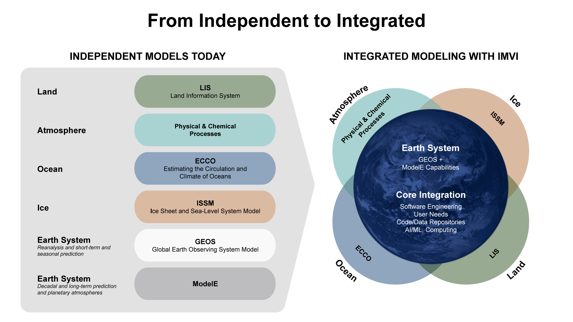
Initially, IMVI prioritizes the coordination of activities and complementary strengths across core capabilities, including process models (such as land, atmosphere, ocean, and ice), global Earth system models, and scientific computing. By further building upon NASA's unique leadership in advanced analysis and predictions of the Earth system, IMVI accelerates scientific discovery, drives technological innovation, and maximizes benefits for stakeholders and the public.
Advancing Earth understanding through core modeling competencies
NASA's advanced Earth system models are a critical national asset, fusing trusted global observations, disciplinary expertise, and innovative techniques to deliver state-of-the-art tools and data products characterizing the Earth’s past, present, and future. IMVI builds upon this leadership to push new boundaries in scientific discovery and maximize the impact of space-based Earth observation.
By coupling process-specific analysis (for example, the movement of sunlight through the atmosphere or water through soil) with global system models, IMVI advances holistic understanding of how complex Earth systems interact. Unique expertise in data assimilation — the process of merging observational data into computer models to improve forecast accuracy — support continued improvement for NASA's Earth projection and prediction capabilities.
Stimulating actionable insights for societal benefit
NASA's Earth system models provide a critical scientific foundation for the actionable insights that society needs. Users rely on the agency's trusted models to support real-world applications such as severe weather forecasting, soil moisture projections for agricultural management, and insurance sector risk assessments.
To maximize this impact, IMVI focuses on strengthening alignment with user needs, accelerating innovative applications, and creating pathways to transition proven tools to operational partners. By actively engaging with user communities, IMVI will continuously improve the relevance, accuracy, and impact of NASA's modeling products.

Ensuring model readiness for next-generation Earth observations
Earth-observing technologies and systems are advancing rapidly, delivering an unprecedented volume of global data. However, integrating new observations into complex computational models is challenging.
IMVI enables simulation exercises that prepare core Earth system models to process new data from upcoming NASA missions. This preparation reduces the time it takes to turn new, raw satellite data into actionable science. Furthermore, increasing access to IMVI models allows missions in development to design measurements that are perfectly tuned for scientific use from day one.
Accelerating science-to-use with innovative technology and capabilities
NASA's Scientific Computing project provides cutting-edge technical infrastructure for IMVI, including code modernization, data interfaces, and AI and machine learning applications. These capabilities are critical for next-generation Earth system modeling, enabling scientists to merge new data, run simulations of Earth system processes more quickly, improve local-scale predictions, and accurately measure the confidence of model predictions.

The Integrated Modeling Virtual Institute (IMVI) harnesses the power of NASA's state-of-the-art Earth system models to push the boundaries of scientific discovery. By enabling deeper understanding of complex Earth processes and enhancing predictive capabilities, IMVI supports real-world applications like weather forecasting, resource management, and artificial intelligence technologies."

DR. KAREN St. Germain
NASA Earth Science Division Director
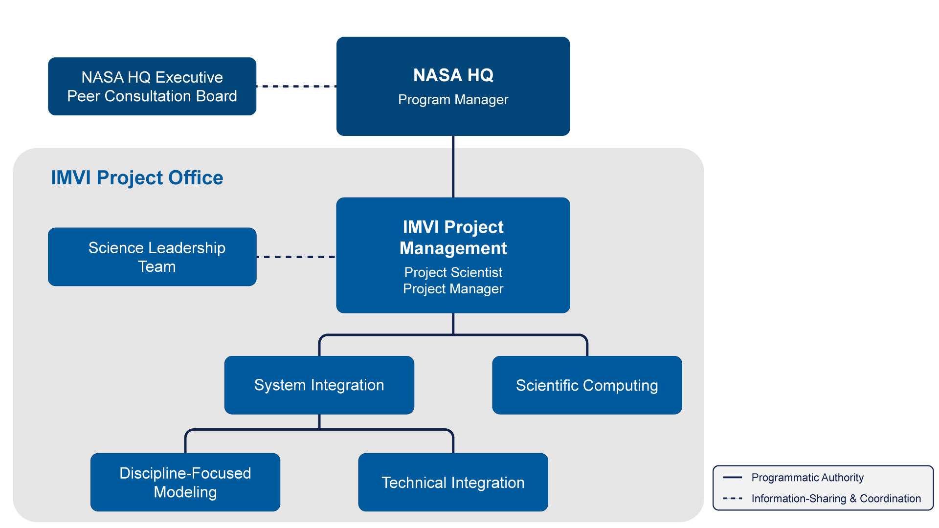
IMVI Project Leadership
| Argyro Kavvada | Program Manager, Integrated Earth System Modeling |
| Lesley Ott | Project Scientist, Integrated Modeling Virtual Institute |
| Joel McCorkel | Project Manager, Integrated Modeling Virtual Institute |