


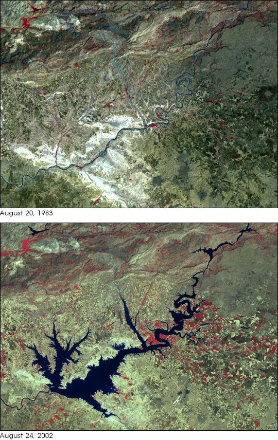
- August 20, 1983 (MSS)(1.9 Mb JPEG)
- August 24, 2002 (ETM+)(1.6 Mb JPEG)
Turkey’s Ataturk Dam was completed in 1990. It is the largest of a series of dams along the two majorrivers of the region, the Tigris and Euphrates, which both have their headwaters in southeasternTurkey. Built both to generate electricity for the region and to irrigate the plains between theEuphrates (on which it sits) and the Tigris (to the east), Ataturk Dam is the centerpiece of a huge public worksprogram within Turkey known as the Southeastern Anatolia Project. When the entire program ofreservoirs, power generation stations, and irrigation channels is constructed,it will irrigate some 1.7 million hectares (4.2 million acres). The reservoir already provides 8.9 billionkilowatt hours of electricity, roughly 22 percent of Turkey’s anticipated electricalneeds in 2010, when the project is expected to be completed. Withthe dam now finished, as well as the first of the irrigation channels,crops such as cotton are being grown in the Harran Plainsin the dry season, where previous irrigation was limited to borewater and much less land wasin active production.
In this pair of Landsat images, the dramatic growth of the Ataturk Dam Lake in the space of19 years is quite apparent. The newly formed lake, sometimes referred to as a sea by locals,covers some 817 square kilometer (320 square miles) in total surface area.
These images were acquired by the Landsat 4 Multispectral Sensor (MSS) and the Landsat 7 Enhanced Thematic Mapper Plus (ETM+) instruments. The first image was acquired by MSS on August 20, 1983, and the second by ETM+ on August 24, 2002. Both false-color composite imageswere constructed by combining near-infrared, red, and green wavelengths (MSS bands 3, 2, and 1;ETM+ bands 4, 3, and 2).
References & Resources
Landsat 4 MSS image obtained from the University of Maryland’s Global Land Cover Facility . Landsat 7 ETM+ image provided courtesy of USDA Foreign Agricultural Service Production Estimates and Crop Assessment Division (PECAD) .
None


