Suggested Searches

1 min read

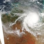
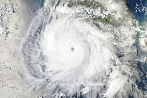
Cyclone Harvey Moves Over Australia

Instruments:
2005-02-07 00:00:00
February 7, 2005

This image from the Moderate Resolution Imaging Spectroradiometer (MODIS) on NASA's Aqua satellite shows Cyclone Harvey in the Gulf of Carpentaria at 4:30 UTC on February 7, 2005. At the time this image was taken, Harvey had maximum sustained winds of 58 mph (50 knots) with maximum gusts near 75 mph (65 knots) and was moving towards the southwest at 15 mph (13 knots). The cyclone was expected to impact the coast on Monday afternoon (local time) near the border between the Northern Territory and Queensland.

References & Resources

NASA image courtesy the MODIS Rapid Response Team at NASA GSFC. The image is available in additional resolutions .
You may also be interested in:

Stay up-to-date with the latest content from NASA as we explore the universe and discover more about our home planet.

Tropical Cyclone Narelle Crosses Australia
3 min read

The powerful storm lashed the northern edge of the continent with damaging winds and drenching rain as it made landfall…

Article
Australia’s “Red Centre” Turns Green
3 min read

Abundant rainfall in February and March 2026 transformed the desert landscape of Central Australia.

Article
Tropical Storm Arthur
2 min read

The first named storm of the 2026 Atlantic hurricane season brought intense rainfall and the threat of flash flooding to…

Article