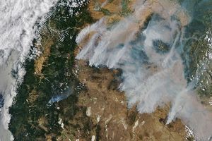


















Satellite images of the western United States showed widespread fire activity across numerous states in July 2007. In Oregon, fires had forced evacuations and closed public forests and parks, while threatening several communities. The largest blaze, the Egley Complex, is located at the bottom center of this image from the Moderate Resolution Imaging Spectroradiometer (MODIS) on NASA’s Terra satellite on July 16, 2007. A second large fire, the Monument Complex, is visible to the north.
The high-resolution image provided above has a spatial resolution of 250 meters per pixel. The MODIS Rapid Response Team provides twice-daily images of the area in a variety of resolutions and formats.
References & Resources
NASA image courtesy the MODIS Rapid Response Team, Goddard Space Flight Center.