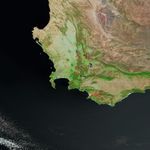

















The effects of bushfires in South Africa to the east and southeast of Cape Town are evident in this shortwave- and near-infrared-enhanced satellite image captured by the Moderate Resolution Imaging Spectroradiometer (MODIS) on NASA’s Terra satellite on February 6, 2006. In the scene, unburned vegetation appears bright green, while burned areas appear bright reddish brown. Naturally bare (or sparsely vegetated) ground appears tan or pink. Water appears dark blue to nearly black, while developed areas appear gray. The large image has a spatial resolution (level of detail) of 250 meters per image pixel. The MODIS Rapid Response Team provides daily images of this area in a variety of resolutions and color combinations.
References & Resources
NASA image courtesy the MODIS Rapid Response Team, Goddard Space Flight Center