











Suggested Searches

1 min read

Haze over Southern California

Instruments:
2007-11-18 00:00:00
November 18, 2007

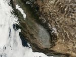
Visible evidence of poor air quality appeared in satellite imagery of California on November 18, 2007. The Moderate Resolution Imaging Spectroradiometer (MODIS) flying on NASA’s Aqua satellite captured this image of haze in southern California, in the San Joaquin Valley. In this picture, the dingy gray haze occupies the southern end of the valley, just east of the Sierra Nevada.

A November 18, 2007, posting on the U.S. Air Quality-Smog Blog at the University of Maryland, Baltimore County, described poor air quality in California in the days prior to this image acquisition.

References & Resources

NASA image courtesy the MODIS Rapid Response Team at NASA GSFC.

You may also be interested in:

Stay up-to-date with the latest content from NASA as we explore the universe and discover more about our home planet.

A Week of Smoky Skies Across North America
3 min read

Brown carbon, emitted by wildland fires and tracked over the span of a week in July 2026, worsened air quality…

Article
Air Pollution’s Daily Pulse Over the Northeast
5 min read

The TEMPO mission helped scientists track morning nitrogen dioxide that contributed to afternoon ozone along the New York–Washington corridor in…

Article
Smoke Streams Across Eastern Washington
3 min read

Wildland fires in early August 2026 pushed air quality to unhealthy levels, destroyed hundreds of structures, and triggered mandatory evacuations…

Article