


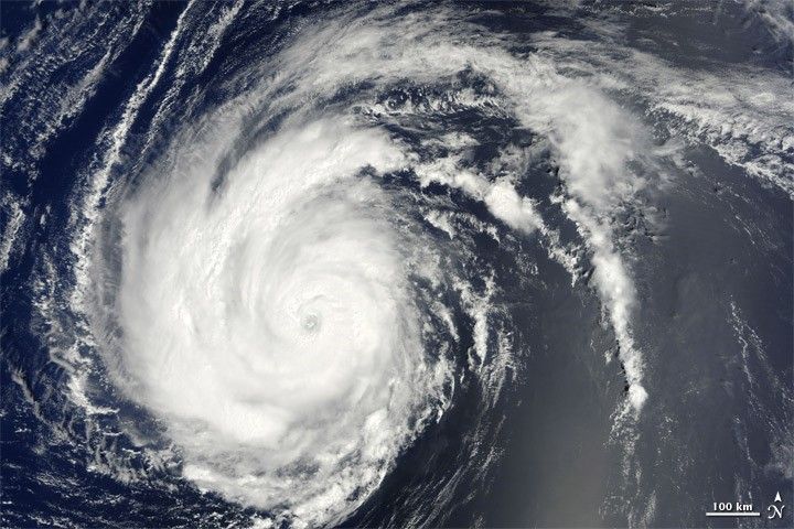
At 2:00 a.m. Atlantic Standard Time (AST) on August 27, 2010, the U.S. National Hurricane Center (NHC) reported that Hurricane Danielle had strengthened into a major hurricane. Nine hours later, the NHC reported that Danielle was a Category 4 hurricane, with maximum sustained winds of 135 miles (215 kilometers) per hour and higher gusts. The storm was about 480 miles (770 kilometers) southeast of Bermuda.
The Moderate Resolution Imaging Spectroradiometer (MODIS) on NASA’s Terra satellite captured this natural-color image of Hurricane Danielle at 10:25 AST (14:25 UTC) on August 27, 2010. Danielle sports a distinct eye in the middle of its spiraling clouds. As it did the previous day, the storm sends its longest spiral arms toward the northeast.
As of 11:00 a.m. August 27, 2010, the NHC reported no coastal watches or warnings, but warned that dangerous surf conditions would affect Bermuda over the next few days. The NHC further forecast that swells from Danielle would start arriving on U.S. East Coast shores on August 28, probably leading to rip currents August 28 and 29.
References & Resources
- National Hurricane Center. (2010, August 27). Hurricane Danielle Advisory Archive. Accessed August 27, 2010.
- Unisys. (2010, August 27). Danielle Tracking Information. Accessed August 27, 2010.
NASA image by Jeff Schmaltz, MODIS Rapid Response Team at NASA GSFC. Caption by Michon Scott.