


![Request for Information – Potential [Placeholder for Prize]](https://assets.science.nasa.gov/dynamicimage/assets/science/psd/solar/2023/09/s/solarsystem_0.jpg?w=1024)


September 2, 2004
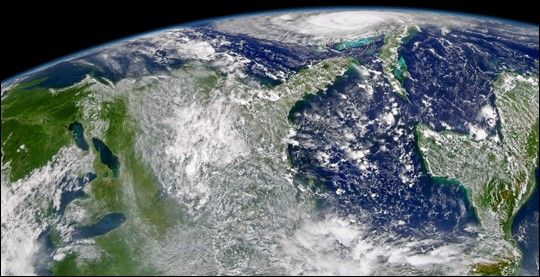
The Sea-Viewing Wide-Field-of-View-Sensor (SeaWiFS) onboard the OrbView-2 satellite captured this oblique view of a very powerful Hurricane Frances on September 2, 2004 at 18:05 UTC (2:05 PM EDT). At the time this image was taken Frances was wreaking havoc on San Salvador Island in the Bahamas with maximum sustained winds of 230 km/hr (145 mph). The latest forecast from the Tropical Predicition Center in Miami has Frances making landfall on Florida's southeast coast on Saturday morning.
References & Resources
Provided by the SeaWiFS Project, NASA/Goddard Space Flight Center, and ORBIMAGE


