


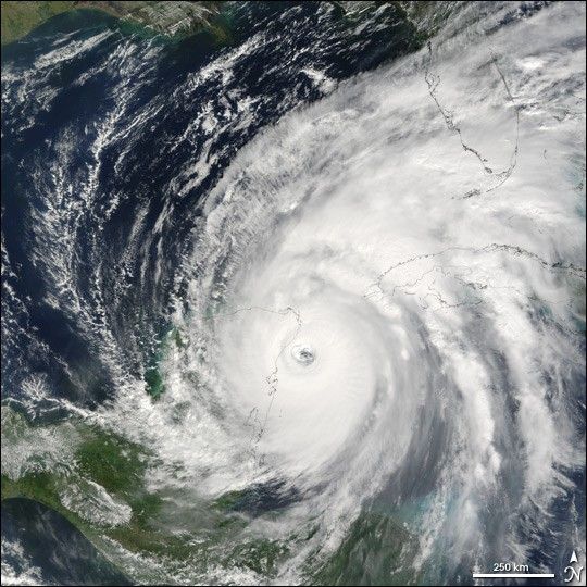
Hurricane Wilma remained a powerful Category 4 storm when the Moderate Resolution Imaging Spectroradiometer (MODIS) on NASA’s Terra satellite took this image at 12:25 p.m. Eastern Daylight Time, on Friday, October 21, 2005. Two days earlier, Wilma had surged from tropical storm to Category 5 hurricane in record time. Winds around the eyewall of the storm were raging at 280 kilometers per hour (175 miles per hour). National Oceanographic and Atmospheric Administration (NOAA) aircraft had also measured a record-low air pressure of 882 millibars in the center of Hurricane Wilma, making it the most intense hurricane ever observed in the Atlantic basin.
Since then, Wilma has lost some of her history-making strength, but this is little comfort to those in her path. In this image, the storm eye is about to cross Cozumel, a small island just off the Yucatan Peninsula coast. Winds were peaking at 230 km/hr (145 mph) as the eyewall passed over the island, and hurricane-strength winds extended for 130 kilometers (85 miles) from the storm’s center. As of Friday afternoon, Wilma was projected to continue into the Gulf of Mexico, bringing powerful winds and heavy rain to both western Cuba and the Yucatan Peninsula before turning toward southern Florida. Florida residents have already begun to prepare for the storm’s arrival.
References & Resources
Terra MODIS data acquired by direct broadcast at the University of South Florida (Judd Taylor). Image processed at the University of Wisconsin-Madison (Liam Gumley)


