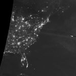
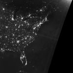
If a power outage spans a large area, there is the chance it can be seen from space. The outage pictured here shows the darkness that fell across parts of North Carolina’s Outer Banks in late July 2017.
The Visible Infrared Imaging Radiometer Suite (VIIRS) on the Suomi NPP satellite captured nighttime images of Hatteras and Ocracoke islands. They show the barrier islands on July 27 (before the blackout) and on July 30, 2017.
Storms are a common culprit for power outages, such as the darkness that ensued after Hurricane Matthew in October 2016. But according to news reports, the power outage pictured here had a more unusual cause—a construction accident that “compromised” buried transmission cables.
References & Resources
- Outer Banks Sentinel (2017, July 30) Update: All three transmission cables damaged. Accessed July 31, 2017.
- Outer Banks Sentinel (2017, July 28) Update: Mandatory visitor evacuation ordered for Hatteras. Accessed July 31, 2017.
- Twitter (2017, July 30) Miguel O. Román (@NASA_Roman). Accessed July 31, 2017.
NASA Earth Observatory image by Jesse Allen, using VIIRS day-night band data from the Suomi National Polar-orbiting Partnership. Caption by Kathryn Hansen.