![Request for Information – Potential [Placeholder for Prize]](https://assets.science.nasa.gov/dynamicimage/assets/science/psd/solar/2023/09/s/solarsystem_0.jpg?w=1024)


animations
small (1.2 MB MPEG)
large (3.3 MB QuickTime)
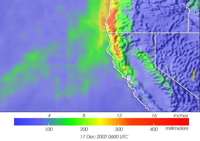
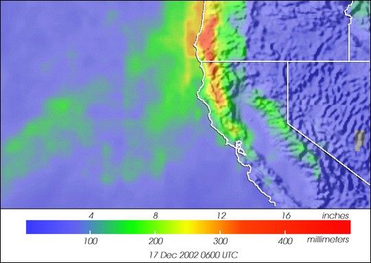
This image shows rainfall accumulation over California and Oregon's Coastal Ranges from December 14 - 17, 2002. The area has beenbattered by a series of North Pacific storms called extratropical lows. Several lives have been lost as a consequence of flooding rains, high winds and significant snow accumulations. The Guadalupeand Napa Rivers in California have overflowed their banks and wind gusts in the 50-80 mph range have occurred. The rain image, based on data from NASA's Tropical Rainfall Measurement Mission (TRMM) satellite shows how mountains dramatically enhance precipitation when moist, southerly winds flow off the ocean and are forced to ascend. Raintotals exceeded 16 inches in many locations. The series of powerful storms may be related to a moderate El Niño currently active acrossthe equatorial Pacific Ocean.
References & Resources
Image courtesy of Hal Pierce, NASA GSFC. More TRMM images may be found at the TRMM Website (http://trmm.gsfc.nasa.gov).