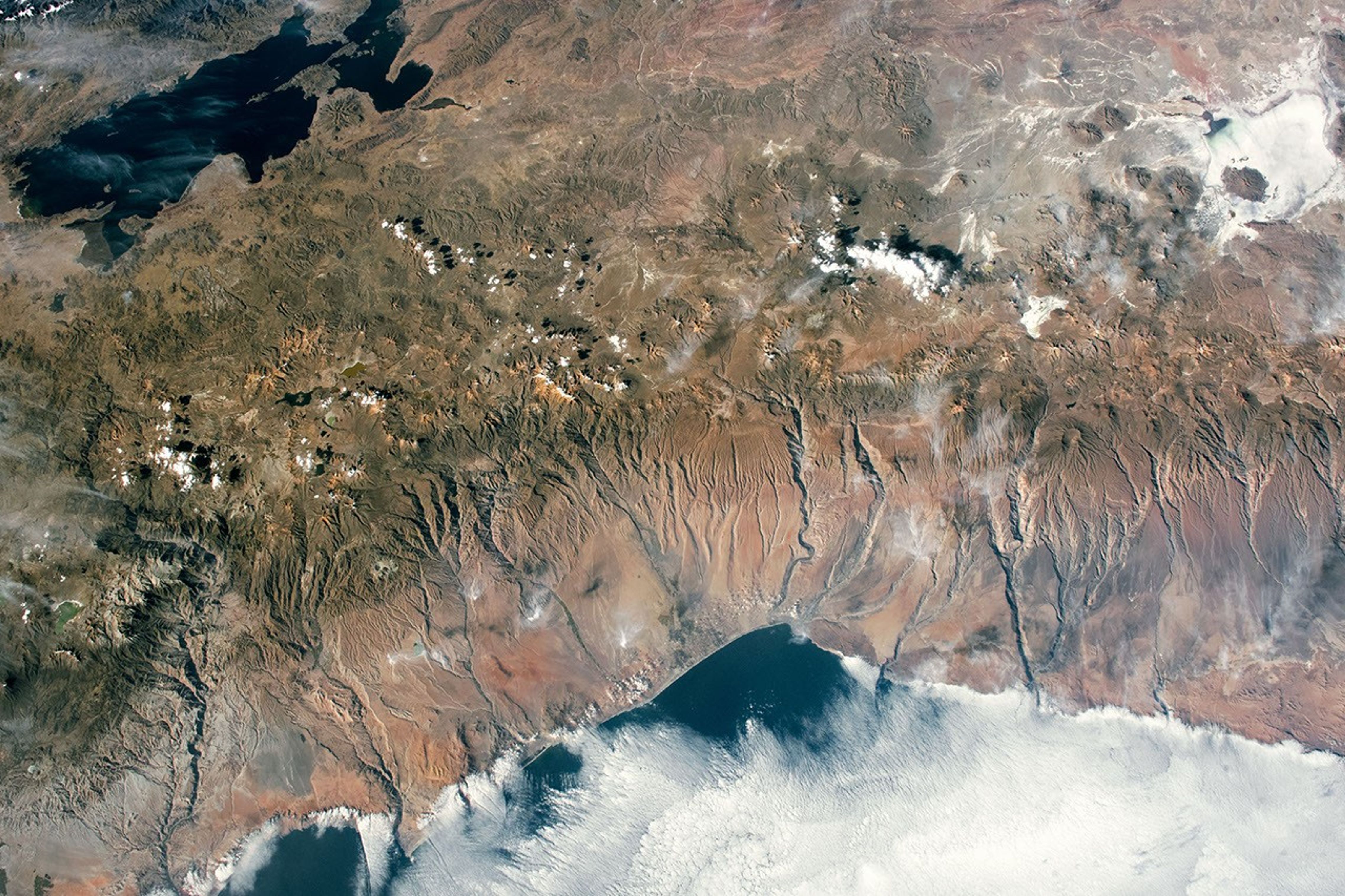


An astronaut aboard the International Space Station captured this photograph while orbiting over the Atacama Desert and Central Andes Mountains near the border of Bolivia, Peru, and Chile.
Over the Pacific Ocean, marine stratocumulus clouds develop over cold water that rises from the ocean depths as the Peru current (Humboldt current) flows north along the west coast of South America. The coastline is marked by low mountains that are dissected by canyons carved by rivers that flow down the western side of the Andes.
Inland of the coastal mountains, the Atacama Desert receives an average annual rainfall of less than 5 millimeters (0.2 inches). This dry environment provides an ideal setting for NASA to conduct Mars analog studies.
Active and inactive volcanoes comprise the Central Andean Volcanic Arc within the Atacama Desert and Andes Mountains. One of the inactive volcanoes visible in this photo is Bolivia’s Nevado Sajama, which has a maximum elevation of 6,542 meters (21,463 feet). Nevado Sajama and other volcanoes in the region often have glaciers and snow cover due to their high elevation.
Toward the top-right of the image, a dry salt lake known as Salar de Coipasa is visible. In the top-left, along the border of Bolivia and Peru, is Lake Titicaca; standing 3,810 meters (12,500 feet) above sea level, it is one of the highest lakes in the world.
References & Resources
Astronaut photograph ISS063-E-51053 was acquired on July 19, 2020, with a Nikon D5 digital camera using a focal length of 28 millimeters. It is provided by the ISS Crew Earth Observations Facility and the Earth Science and Remote Sensing Unit, Johnson Space Center. The image was taken by a member of the Expedition 63 crew. The image has been cropped and enhanced to improve contrast, and lens artifacts have been removed. The International Space Station Program supports the laboratory as part of the ISS National Lab to help astronauts take pictures of Earth that will be of the greatest value to scientists and the public, and to make those images freely available on the Internet. Additional images taken by astronauts and cosmonauts can be viewed at the NASA/JSC Gateway to Astronaut Photography of Earth. Caption by Francesca Filippone, Texas State University, Jacobs Technology, JETS Contract at NASA-JSC.