January 9, 2014
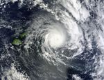
Tropical Cyclone Ian was skirting Fiji when the Moderate Resolution Imaging Spectroradiometer (MODIS) on NASA’s Aqua satellite acquired this image at 2:55 p.m. (1:55 Universal Time) on January 9, 2014. The storm had winds of 85 knots (157 kph or 98 mph), making it the equivalent of a category 2 hurricane. The Joint Typhoon Warning Center forecast that Ian would intensify over the next 24 hours as it moved east and south toward Tonga.
References & Resources
- Australia News Network (2013, January 9) Cyclone Ian approaching Tonga with ‘catastrophic’ winds. Accessed January 9, 2014.
- Joint Typhoon Warning Center (2014, January 9) Tropical Cyclone 07P (Ian) warning #8 issued at 09/0900Z. Accessed January 9, 2014.
NASA image courtesy Jeff Schmaltz, LANCE/EOSDIS MODIS Rapid Response Team at NASA GSFC. Caption by Holli Riebeek.