Suggested Searches

1 min read

Typhoon Sudal

Instruments:
2004-04-08 00:00:00
April 8, 2004

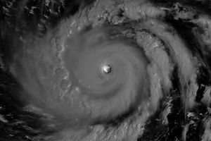
The MODIS instrument on board NASA's Aqua satellite captured this true-color image of Typhoon Sudal located about 95 miles east-southeast of Yap. Sudal was moving towards the west-southwest around 9 mph and was packing sustained winds of 120 mph with gusts to 150 mph. Sudal was expected to pass very close to the island of Yap on Friday morning, local standard time.

References & Resources

Image courtesy Jacques Descloitres, MODIS Land Rapid Response Team at NASA GSFC.

You may also be interested in:

Stay up-to-date with the latest content from NASA as we explore the universe and discover more about our home planet.

A Sea of Spinning Clouds
3 min read

Icy, isolated Peter I Island stirred up a show in the atmosphere off the West Antarctic coast.

Article
Showy Swirls Around Jeju Island
2 min read

Winds blowing past the volcanic landmass near the Korean Peninsula created a trail of spiraling clouds, while murky water churned…

Article
America’s Emerald Isle
3 min read

Beaver Island is one in a string of verdant and scenic jewels in a northern Lake Michigan archipelago.

Article