


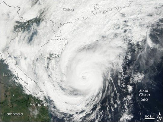
Typhoon Utor struck the Philippines on December 9, 2006. Coming just a week after Super Typhoon Durian passed through the island chain on a parallel path to the north, Utor brought heavy rain and strong winds to sodden ground and swollen rivers. Xangsane, Cimaron, and Chebi earlier in the year had also followed very similar tracks to Utor. Like Durian before it, Utor crossed the South China Sea and come ashore in mainland Asia along the Vietnam coast.
This photo-like image was acquired by the Moderate Resolution Imaging Spectroradiometer (MODIS) on the Terra satellite on December 13, 2006, at 10:05 a.m. local time (3:05 UTC), while the storm’s center was still far off the Vietnam coast. The storm system had the well-defined shape of a powerful typhoon, with a cloud-filled but distinct eye. Utor brought strong winds and rain over a wide area from southern China to Thailand and beyond, even though the typhoon’s center was well offshore. Sustained winds were around 175 kilometers per hour (110 miles per hour), according to the University of Hawaii’s Tropical Storm Information Center.
You can also download a 250-meter-resolution Typhoon Utor KMZ file for use with Google Earth.
References & Resources
NASA image by Jesse Allen, Earth Observatory, using data provided courtesy of the MODIS Rapid Response Team, Goddard Space Flight Center.


