


before
after

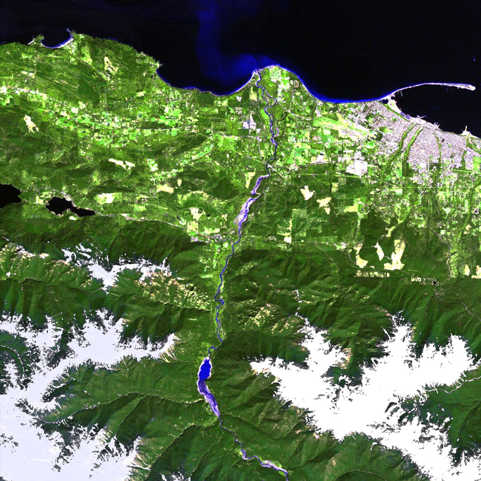
The Elwha and Glines Canyon dams were built in the 1920s to provide hydroelectric power. But the machinery became outdated over the decades and the reservoirs grew heavily silted. Further, the dams prevented salmon from reaching upstream habitat. The Elwha dam was removed in early 2012 and these images show the results in the Elwha River basin of the Washington State Olympic Peninsula. In the 2012 image, the reservoir behind the dam is gone, the exposed silt deposits are gradually diminishing, and natural river flow is returning. The Glines Canyon dam is scheduled for removal by late 2013. Images taken by the Thematic Mapper sensor onboard Landsat 5 and the Enhanced Thematic Mapper Plus onboard Landsat 7. Source: U.S. Geological Survey (USGS) Landsat Missions Gallery, "Elwha River restoration," U.S. Department of the Interior / USGS and NASA.
The Elwha and Glines Canyon dams were built in the 1920s to provide hydroelectric power. But the machinery became outdated over the decades and the reservoirs grew heavily silted. Further, the dams prevented salmon from reaching upstream habitat. The Elwha dam was removed in early 2012 and these images show the results in the Elwha River basin of the Washington State Olympic Peninsula. In the 2012 image, the reservoir behind the dam is gone, the exposed silt deposits are gradually diminishing, and natural river flow is returning. The Glines Canyon dam is scheduled for removal by late 2013. Images taken by the Thematic Mapper sensor onboard Landsat 5 and the Enhanced Thematic Mapper Plus onboard Landsat 7. Source: U.S. Geological Survey (USGS) Landsat Missions Gallery, "Elwha River restoration," U.S. Department of the Interior / USGS and NASA.
The Elwha and Glines Canyon dams were built in the 1920s to provide hydroelectric power. But the machinery became outdated over the decades and the reservoirs grew heavily silted. Further, the dams prevented salmon from reaching upstream habitat. The Elwha dam was removed in early 2012 and these images show the results in the Elwha River basin of the Washington State Olympic Peninsula. In the 2012 image, the reservoir behind the dam is gone, the exposed silt deposits are gradually diminishing, and natural river flow is returning. The Glines Canyon dam is scheduled for removal by late 2013. Images taken by the Thematic Mapper sensor onboard Landsat 5 and the Enhanced Thematic Mapper Plus onboard Landsat 7. Source: U.S. Geological Survey (USGS) Landsat Missions Gallery, "Elwha River restoration," U.S. Department of the Interior / USGS and NASA.
The Elwha and Glines Canyon dams were built in the 1920s to provide hydroelectric power. But the machinery became outdated over the decades and the reservoirs grew heavily silted. Further, the dams prevented salmon from reaching upstream habitat. The Elwha dam was removed in early 2012 and these images show the results in the Elwha River basin of the Washington State Olympic Peninsula. In the 2012 image, the reservoir behind the dam is gone, the exposed silt deposits are gradually diminishing, and natural river flow is returning. The Glines Canyon dam is scheduled for removal by late 2013. Images taken by the Thematic Mapper sensor onboard Landsat 5 and the Enhanced Thematic Mapper Plus onboard Landsat 7. Source: U.S. Geological Survey (USGS) Landsat Missions Gallery, "Elwha River restoration," U.S. Department of the Interior / USGS and NASA.
before
after
Before and After
Elwha dam removal, Washington State
July 5, 2011 - May 12, 2012
The Elwha and Glines Canyon dams were built in the 1920s to provide hydroelectric power. But the machinery became outdated over the decades and the reservoirs grew heavily silted. Further, the dams prevented salmon from reaching upstream habitat. The Elwha dam was removed in early 2012 and these images show the results in the Elwha River basin of the Washington State Olympic Peninsula. In the 2012 image, the reservoir behind the dam is gone, the exposed silt deposits are gradually diminishing, and natural river flow is returning. The Glines Canyon dam is scheduled for removal by late 2013. Images taken by the Thematic Mapper sensor onboard Landsat 5 and the Enhanced Thematic Mapper Plus onboard Landsat 7. Source: U.S. Geological Survey (USGS) Landsat Missions Gallery, "Elwha River restoration," U.S. Department of the Interior / USGS and NASA.


