


Severe Storms
Every day, severe storms impact life and property by causing flooding, damaging winds and hail, lightning strikes, and more. NASA develops instruments and missions to observe these sometimes destructive events from space, the air, and the ground – information that U.S. and international weather forecasting agencies use to improve forecasts and help keep us safe.
Where Does NASA Fit?
Severe storms create significant hazards around the world, endangering humans and other living things and threatening property and infrastructure. NASA remote sensing instruments measure meteorological conditions, track storm lifespans, and gather data on their impacts from space, in the air, and the ground. These observations help researchers better understand the atmosphere and develop computer models to study future storms. NASA frequently partners with the National Oceanic and Atmospheric Administration (NOAA) to develop, launch, and manage satellites and instruments that contribute to storm research. The data fuels weather forecasting by NOAA, the U.S. Department of Defense, and other institutions, and gives researchers and decisionmakers critical information to understand, anticipate, and respond to severe storms.
What Are Severe Storms?
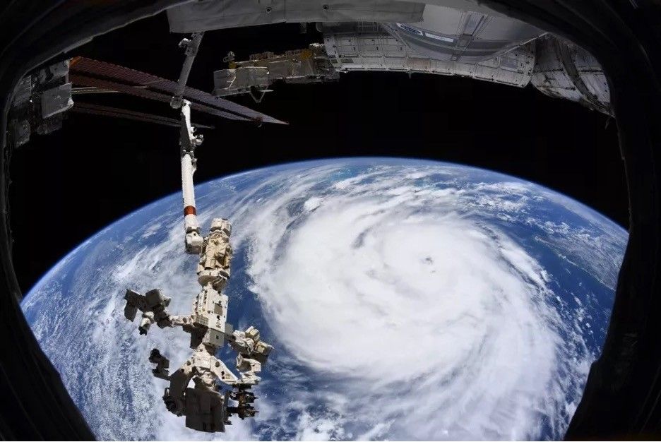
With the right combination of air pressure, temperature, moisture, wind, and other meteorological variables, Earth’s atmosphere can become disturbed, resulting in stormy weather. A weather disturbance is classified as severe if it can pose a risk to life and property in the form of damaging winds, intense rainfall, large hail, lightning, or freezing rain and snow. Tropical cyclones (which include hurricanes), severe thunderstorms, tornadoes, blizzards, derechos, and strong atmospheric rivers are all examples of severe storms.
Learn MoreHurricane Helene
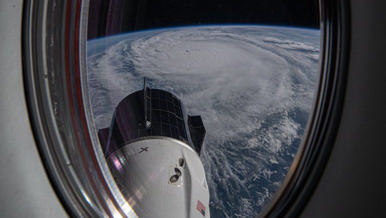
Hurricane Helene devastated portions of the Southeast U.S. in 2024 with winds, rain, and storm surges. NASA spaceborne instruments monitored the storm’s flooding, impacts on coastal waters, power outages, precipitation totals, the ocean heat content that helped fuel the storm, and more, providing invaluable data to support agencies responding to the storm.
Read More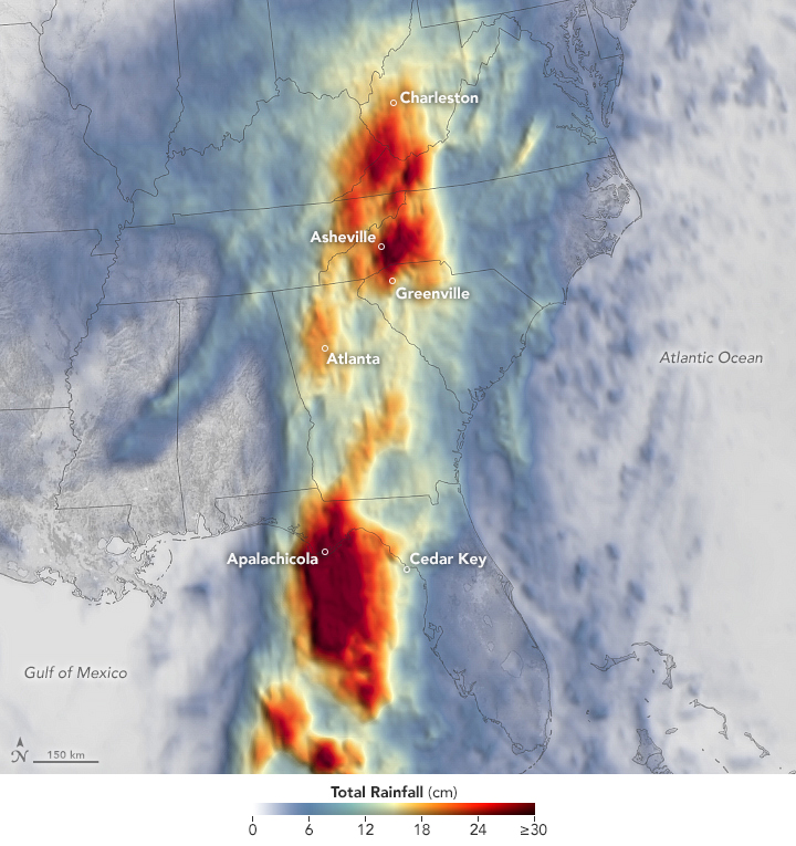
Global Precipitation Measurement (GPM)
The joint NASA-JAXA Global Precipitation Measurement (GPM) satellite mission measures Earth's rain and snowfall for the benefit of humanity.
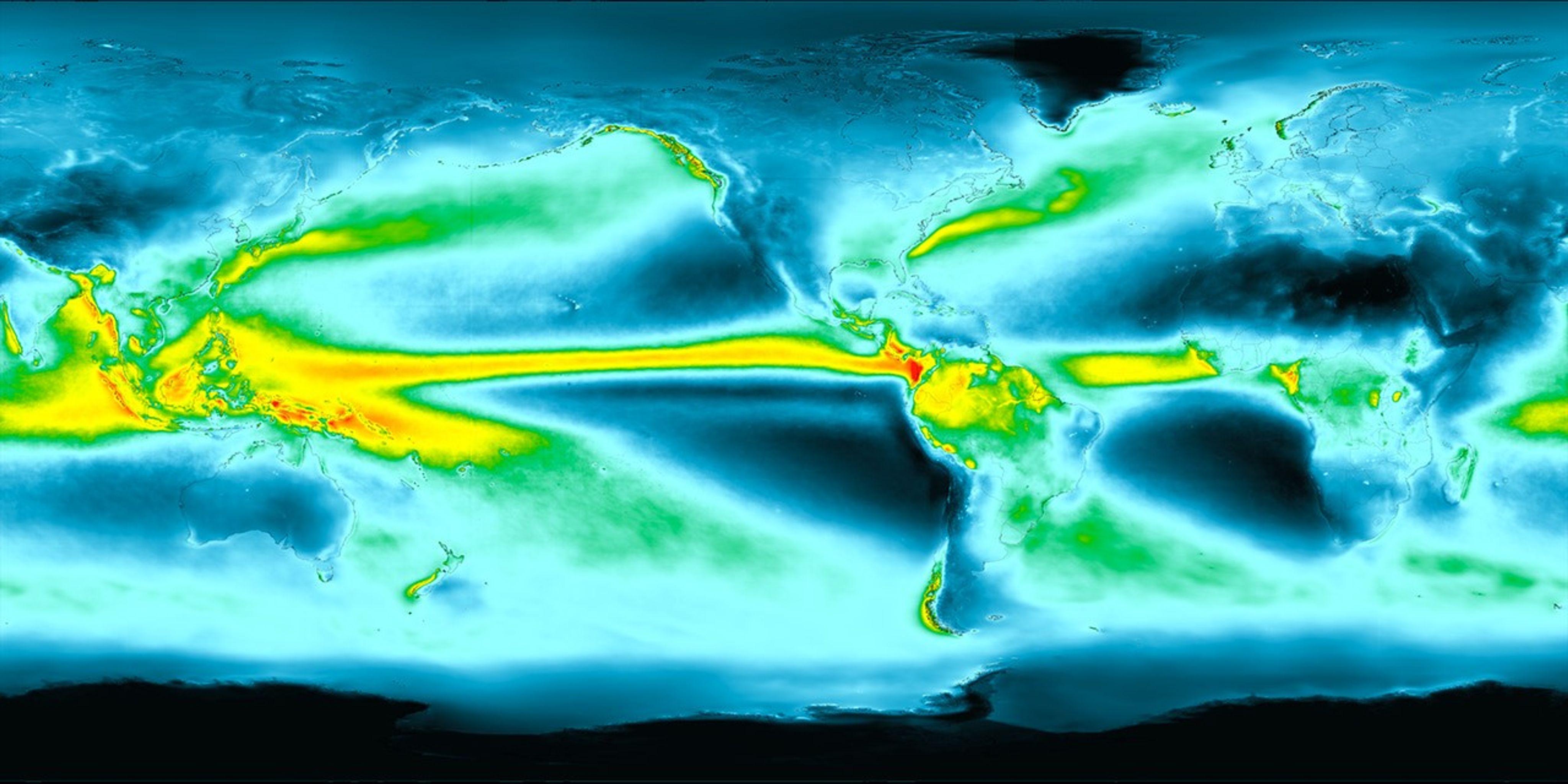
Inside Hurricane Maria in 360°
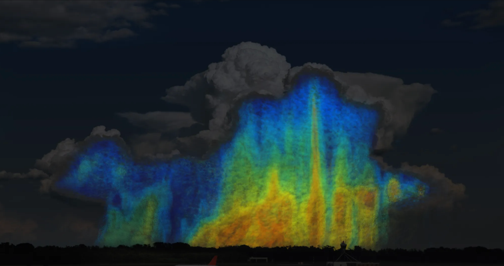
Two days before Hurricane Maria devastated Puerto Rico, the NASA-JAXA Global Precipitation Measurement Core Observatory satellite captured a 3-D view of the storm, revealing the processes inside the hurricane that would fuel the storm’s rapid intensification. Those processes are on full display in this 360-degree data visualization that takes you inside the storm.
The satellite’s advanced radar measures both liquid and frozen water. The green and yellow indicate low rainfall rates, while the red and purple dots represent high rates. At the top of the hurricane, where temperatures are colder, blue and purple dots signal light and heavy frozen precipitation. The colored areas below the dots show how much rain is falling at the surface.
How NASA Helps
-
Earth Action: NASA Disasters Program
The NASA Disasters Program advances science and builds tools to help communities make informed decisions for disaster planning.
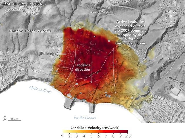 The NASA Jet Propulsion Laboratory/Caltech Advanced Rapid Imaging and Analysis (ARIA) team used data from NASA's Uninhabited Aerial Vehicle Synthetic Aperture Radar (UAVSAR) airborne instrument to measure accelerated movement of ancient, slow-moving landslides in Los Angeles County's Palos Verdes Peninsula in fall 2024. The accelerated movement was triggered by record-breaking rainfall in 2023-24.NASA Earth Observatory
A Decade of Global Precipitation
For 10 years, through rain and snow, hurricane, typhoon and monsoon, flash flood and bomb cyclone, the joint NASA-JAXA Global Precipitation Measurement mission has measured a lot of water. Knowing how much rain or snow falls, and when and where, will improve our understanding of Earth’s weather and climate cycles.
Video Source-
NASA AI, Open Science Advance Disaster Research and Recovery
NASA scientists work with IBM to develop open-source artificial intelligence models that are trained on NASA’s expansive repository of satellite imagery. The models help communities make more informed decisions on planning for and responding to disasters such as hurricanes.
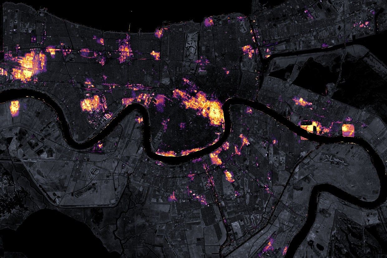 NASA Earth Observatory images by Joshua Stevens, using Black Marble data courtesy of Ranjay Shrestha/NASA Goddard Space Flight Center and Landsat data from the U.S. Geological Survey.
50 Years of GOES
For five decades, NOAA and NASA have partnered to advance NOAA satellite observations from geostationary orbit. The five operational GOES satellites currently in orbit keep constant watch for severe weather and environmental hazards on Earth and dangerous space weather.
Video SourceSevere Storm News
Explore NASA's media galleries to view and download high-resolution images of the solar system, agency missions, and more.
Global Collaboration Leads to New Discoveries in Lightning Research

SWOT Satellite Catches Coastal Flooding During California Storms
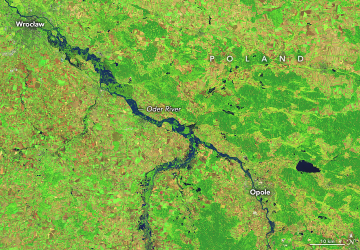
Rivers in Europe Burst Their Banks
Torrential rain from a stalled storm system caused flooding in countries such as Poland and Slovakia.
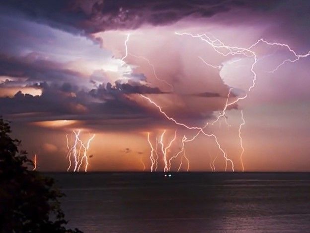
A New Look at Earth’s Lightning
A sensor installed on the International Space Station is yielding fresh insights on the global distribution of lightning.
Show Me the Data
Show Me the Data
Current Research

NASA Satellite Data Used to Assess Tornado Damage, Understand Storms
As people across the Midwestern U.S. take stock of the devastation from a Dec. 10, 2021 trail of tornados that touched down across the region, data and images from NASA Earth-observing satellites aid first responders and recovery agencies in assessing the damage, and help researchers understand the nature of these unusually powerful storms.
NASA-developed Technology Supports Ocean Wind Speed Measurements from Commercial Satellite
A science antenna developed with support from NASA’s Earth Science Technology Office (ESTO) travels in low-Earth orbit aboard MuSat2, a commercial remote-sensing satellite flown by the aerospace company Muon Space. Aboard MuSat2, the antenna will help measure ocean surface wind speed—an essential data point for scientists trying to forecast how severe a burgeoning hurricane will become.
Additional Missions and Campaigns
NASA
Disasters Mapping Portal
The NASA Disasters Mapping Portal allows users to view, analyze, and download the latest near-real-time and disaster-specific data products in Geographic Information Systems (GIS) format. The Disasters Mapping Portal supports NASA’s Earth Applied Sciences Disasters program area in its mission to use Earth-observing data and applied research to improve the prediction of, preparation for, response to, and recovery from hazards and disasters around the world.
NASA LANCE
NASA’s Land, Atmosphere Near-real-time Capability for EOS (LANCE) provides near-real-time (within 3 hours) satellite data and imagery for use in the fields of numerical weather and climate prediction, natural hazard forecasting and monitoring, agriculture, air quality, and disaster relief.