5 min read

NASA Is Helping Protect Tigers, Jaguars, and Elephants. Here’s How.

Two orange and black-striped tigers rest on their bellies in snow and look directly at the camera.
NASA satellites are helping track tiger habitat, offering new insights for conservation as these predators face the consequences of habitat loss.
Credits: Wildlife Conservation Society / Dale Miquelle

As human populations grow, habitat loss threatens many creatures. Mapping wildlife habitat using satellites is a rapidly expanding area of ecology, and NASA satellites play a crucial role in these efforts. Tigers, jaguars, and elephants are a few of the vulnerable animals whose habitats NASA is helping track from space.

“Satellites observe vast areas of Earth's surface on daily to weekly schedules,” said Keith Gaddis, ecological conservation program manager at NASA Headquarters in Washington. “That helps scientists monitor habitats that would be logistically challenging and time-consuming to survey from the ground — crucial for animals like tigers that roam large territories.”

Here’s how NASA and its partners help protect three of Earth’s most iconic species:

Trouble (and Hope) for Tigers

Tigers have lost at least 93% of their historical range, which once spanned Eurasia. Roughly 3,700 to 5,500 wild tigers remain, up from an estimated low of 3,200 in 2010.

In a recent study, researchers reviewed over 500 studies that contained data on tigers and their habitat across Asia. The team found that the area where the big cats are known to live declined 11%, from about 396,000 square miles in 2001 to about 352,000 square miles in 2020.

Led by the Wildlife Conservation Society (WCS) and funded by NASA’s Ecological Conservation program, the team developed a tool that uses Google Earth Engine and NASA Earth observations to monitor changes in tiger habitat. The goal: aid conservation efforts in near-real time, using data from the Visible Infrared Imaging Radiometer Suite (VIIRS) and Moderate Resolution Imaging Spectroradiometer (MODIS) imagers, and Landsat satellites.

The researchers mapped large stretches of “empty forests” without recent tiger presence. Because these areas were suitable habitat and are still big enough to support tigers, they are potential landscapes for restoration, assuming there is enough food. If tigers could reach those areas, either through natural dispersal or active reintroduction, it could “increase the land base for tigers by 50%,” the scientists reported.

“There’s still a lot more room for tigers in the world than even tiger experts thought,” said lead author Eric Sanderson, formerly a senior conservation ecologist at WCS and now vice president of urban conservation at the New York Botanical Garden. “We were only able to figure that out because we brought together all of this data from NASA and integrated it with information from the field.”

Where the Jaguars Are

Jaguars once roamed from the U.S. Southwest to Argentina. But in the past century, they have lost about 50% of their range, according to the International Union for Conservation of Nature (IUCN). Like tigers, jaguars must contend with poaching and the loss of food sources. Wild jaguars number between 64,000 and 173,000 individuals, and IUCN classifies them as near-threatened.

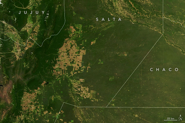
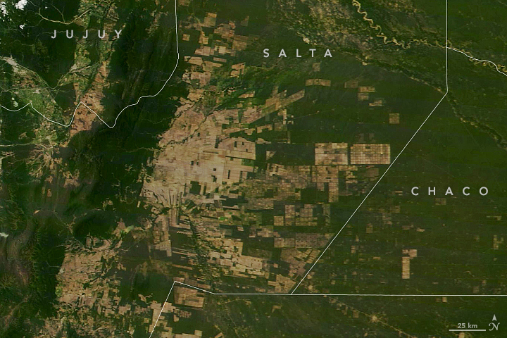
In Gran Chaco, South America’s second largest woodland, jaguars and other animals live in an especially threatened ecosystem. The dry lowland forest stretches from northern Argentina into Bolivia, Paraguay, and Brazil, and has experienced severe deforestation.

before , image shows a landscape mostly dominated by dark green vegetation.
after , image shows many more patches of brown land where trees have been cut down.

Before and After

Gran Chaco Deforestation

Dec, 2000 – Dec, 2019

Jaguars in Argentina’s Chaco may number in the hundreds. Using data on land use and infrastructure, plus Earth observations from MODIS and Landsat, NASA-funded researchers mapped priority conservation areas for jaguars and other important animals. About 36% of the priority areas in Argentina’s Chaco are currently “low-protection” zones, where deforestation is allowed.

“Managers and conservationists could use the new spatial information to see where current forest zoning is protecting key animals, and where it may need re-evaluation,” said lead author Sebastian Martinuzzi of the University of Wisconsin–Madison.

Elephants Seek Out Forest Havens

African savanna elephants now occupy an estimated 15% of their historical range, and their numbers have declined. One study surveyed about 90% of the elephants’ range and estimated that their numbers dropped by 144,000 elephants from 2007 to 2014, leaving approximately 352,000 individuals. In 2021, the IUCN updated the elephants’ status to endangered.

A recent study used NASA satellite-derived vegetation indices and other data to study elephants in Kenya’s Maasai Mara National Reserve, and in nearby semi-protected and unprotected zones. Researchers found that, especially in the unprotected areas, the elephants preferred dense canopy forest, particularly along streams, and avoided open areas like grasslands, especially when more people are present. Human development, such as tourism lodges, is often built in such forests.

Prioritizing elephants’ access to forests in unprotected areas should be of utmost importance for land managers, the researchers said. Because the elephants avoided grasslands, some of those areas could be used for development or livestock — balancing need for economic development and elephant habitat.

The IUCN likewise classifies Asian elephants as endangered. In southern Bhutan, crop depredation and wildlife approaching human settlements is escalating conflicts between people and elephants. In 2020–2021, Bhutanese scholars studying in the United States were selected to participate in the NASA Capacity Building Program’s DEVELOP program. Partnering with the Bhutan Foundation, Bhutan Tiger Center, and Bhutan Ecological Society, the teams used NASA Earth observations, elephant occurrence data, and other information to model current habitat suitability and map wildlife pathways between habitats, aiding strategies that reduce the risk of conflict.

By Emily DeMarco

NASA’s Earth Science Division, Headquarters

Share

Details

Last Updated
May 02, 2024
Editor
Emily DeMarco
Contact
Emily DeMarco
emily.p.demarco@nasa.gov
Location
NASA Headquarters

Related Terms

Keep Exploring

Discover More Topics From NASA