TIROS
Television Infrared Observation Satellite Program
Type
Launch
Location
Objective
The Television Infrared Observation Satellite Program (TIROS)
The TIROS Program (Television Infrared Observation Satellite) was NASA's first experimental step to determine if satellites could be useful in the study of the Earth. At that time, the effectiveness of satellite observations was still unproven. Since satellites were a new technology, the TIROS Program also tested various design issues for spacecraft: instruments, data and operational parameters. The goal was to improve satellite applications for Earth-bound decisions, such as "should we evacuate the coast because of the hurricane?".
The TIROS Program's first priority was the development of a meteorological satellite information system. Weather forecasting was deemed the most promising application of space-based observations.
TIROS proved extremely successful, providing the first accurate weather forecasts based on data gathered from space. TIROS began continuous coverage of the Earth's weather in 1962, and was used by meteorologists worldwide. The program's success with many instrument types and orbital configurations lead to the development of more sophisticated meteorological observation satellites.
TIROS-1
Objectives: To test experimental television techniques designed to develop a worldwide meteorological satellite information system. To test Sun angle and horizon sensor systems for spacecraft orientation.
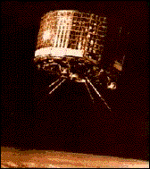
Description: The spacecraft was 42 inches in diameter, 19 inches high and weighed 270 pounds. The craft was made of aluminum alloy and stainless steel which was then covered by 9200 solar cells. The solar cells served to charge the on-board batteries. Three pairs of solid-propellant spin rockets were mounted on the base plate.
Two television cameras were housed in the craft, one low-resolution and one high-resolution. A magnetic tape recorder for each camera was supplied for storing photographs while the satellite was out of range of the ground station network.
The antennas consisted of four rods from the base plate to serve as transmitters and one vertical rod from the center of the top plate to serve as a receiver.
The craft was spin-stabilized and space-oriented (not Earth-oriented). Therefore, the cameras were only operated while they were pointing at the Earth when that portion of the Earth was in sunlight.
The video systems relayed thousands of pictures containing cloud-cover views of the Earth. Early photographs provided information concerning the structure of large-scale cloud regimes.
TIROS-I was operational for only 78 days, but proved that satellites could be a useful tools for surveying global weather conditions from space.
Participants: NASA, US ARMY Signal Research and Development Lab, RCA, US Weather Bureau, US Naval Photographic Interpretation Center.
TRIOS-1 Stats:
- Launch Date: April 1, 1960
- Operational Period: 78 days
- Launch Vehicle: Standard Thor-Able
- Launch Site: Cape Canaveral, FL
- Type: Weather Satellite
TIROS-2
Objectives: To test the experimental television techniques and infrared equipment designed to develop a worldwide meteorological satellite information system. To evaluate a new attitude control system for spacecraft orientation which utilizes the Earth's magnetic field.
Description: The spacecraft was 42 inches in diameter, 19 inches high and weighed 280 pounds. The craft was made of aluminum alloy and stainless steel which was then covered by 9260 solar cells. The solar cells served to charge the nicad batteries. Two television cameras were housed in the craft, one low-resolution and one high-resolution. A magnetic tape recorder for each camera was supplied for storing photographs while the satellite was out of range of the ground station network. In addition, an infrared horizon sensor for attitude control, a direction indicator for picture orientation, two infrared radiation experiments, and a magnetic orientation control experiment were included.
The spacecraft was 42 inches in diameter, 19 inches high and weighed 280 pounds. The craft was made of aluminum alloy and stainless steel which was then covered by 9260 solar cells. The solar cells served to charge the nicad batteries. Two television cameras were housed in the craft, one low-resolution and one high-resolution. A magnetic tape recorder for each camera was supplied for storing photographs while the satellite was out of range of the ground station network. In addition, an infrared horizon sensor for attitude control, a direction indicator for picture orientation, two infrared radiation experiments, and a magnetic orientation control experiment were included.
The antennas consisted of four rods from the base plate to serve as transmitters and one vertical rod from the center of the top plate to serve as a receiver. The video systems relayed thousands of pictures containing cloud-cover views of the Earth. Early photographs provided information concerning the structure of large-scale cloud regimes. In addition, the experiment to partially control the orientation of the satellite spin axis was successful, as was the experiment with infrared sensors.
Participants: NASA, US ARMY Signal Research and Development Lab, RCA, US Weather Bureau, US Naval Photographic Interpretation Center.
TIROS-2 Stats:
- Launch Date: November, 23, 1960
- Operational Period: 376 days
- Launch Vehicle: Three-stage Delta
- Launch Site: Cape Canaveral, FL
- Type: Weather Satellite
TIROS-3
Objectives: Continued development of the experimental television techniques and infrared equipment leading to a worldwide meteorological information system. To obtain infrared measurements of the solar energy absorbed, reflected and emitted by the Earth.
Description: The spacecraft was 42 inches in diameter, 19 inches high and weighed 285 pounds. The craft was made of aluminum alloy and stainless steel then covered by 9260 solar cells. The solar cells served to charge the nickel-cadmium batteries. Three major changes were made from the previous TIROS models. Two wide-angle television cameras were housed in the craft in place of one high-resolution and one low-resolution camera.
A new infrared experiment and improved remote control programmers were also new additions. This craft contained an electronic clock to control the operations of the infrared horizon sensor as well as the magnetic orientation system. A magnetic tape recorder was still provided for each camera to store photographs while the satellite was out of range of the ground station network. One scanning and two non-scanning radiometers were also on board.
The antennas were of the same configuration as both previous TIROS models. Although one of the cameras failed 12 days into the mission, photograph quality from the other camera was excellent and many tropical storms during the 1961 hurricane season were photographed. TIROS-3 was also credited with the discovery of Hurricane Esther.
Participants: NASA, RCA, US Weather Bureau, Barnes Engineering.
TIROS-3 Stats:
- Launch Date: July 12, 1961
- Operational Period: 230 days
- Launch Vehicle: Three-stage Delta
- Launch Site: Cape Canaveral, FL
- Type: Weather Satellite
TIROS-4
Objectives: Continued research into and development of the meteorological satellite information system. This mission was designed to maintain an operational TIROS in orbit for an extended period of time and to obtain improved data for operational use in weather forecasting during the northern hemisphere hurricane season.
Description: The spacecraft was 42 inches in diameter, 19 inches high and weighed 285 pounds. The craft was made of aluminum alloy and stainless steel and was then covered by 9260 solar cells. The solar cells served to charge the 63 on-board batteries.
A new lens system was implemented for this launch. The lens was designed to reduce distortion and improve resolution. This craft also contained an electronic clock to control the operations of the infrared horizon sensor as well as the magnetic orientation control system. A magnetic tape recorder was still provided for each camera to store photographs while the satellite was out of range of the ground station network. One scanning and two non-scanning radiometers were also on board. The transmitting and receiving antennas were of the same configuration as the previous TIROS models.
TIROS-4 pictures were the best to date, allowing the US Weather Bureau to initiate an international facsimile transmission network in order to share the cloud pictures with weather services around the world.
Participants: NASA, RCA, US Weather Bureau, Barnes Engineering
TIROS-4 Stats:
- Launch Date: February 8, 1962
- Operational Period: 161 days
- Launch Vehicle: Three-stage Delta
- Launch Site: Cape Canaveral, FL
- Type: Weather Satellite
TIROS-5
Objectives: Continued research into and development of the meteorological satellite information system. This mission was designed to maintain an operational TIROS in orbit for an extended period of time and to obtain improved data for operational use in weather forecasting during the northern hemisphere hurricane season.
Description: The spacecraft was 42 inches in diameter, 22 inches high and weighed 285 pounds. The craft was made of aluminum alloy and stainless steel and was then covered by 9260 solar cells. The solar cells served to charge the 63 on-board batteries.
This craft contained all of the instrumentation of TIROS-4 as well as a north direction indicator, and despin weights and spinup rockets in an attempt to improve the craft's longevity. TIROS-5 was also launched at a higher inclination (58 degrees vs. 48 degrees on all previous flights) to provide better observations at higher latitudes. The orbitwas elliptical instead of circular due to a Delta ground guidance failure. In addition the three radiation sensors had to be disconnected prior to launch when they failed preflight checks.
TIROS-5 pictures were the best to date, including the observation ofice break-up at northern latitudes
Participants: NASA, RCA, US Weather Bureau
TIROS-5 Stats:
- Launch Date: June 19, 1962
- Operational Period: 161 days
- Launch Vehicle: Three-stage Delta
- Launch Site: Cape Canaveral, FL
- Type: Weather Satellite
TIROS-6
Objectives: Continue research and development of the meteorological satellite information system; prove TIROS could stay in orbit for an extended period of time; obtain improved data for use in weather forecasting during hurricane season; provide operational support for the Mercury-Atlas 8 launch on October 3, 1962.
Description: The spacecraft was 42 inches in diameter, 19 inches high and weighed 270 pounds. The craft was made of aluminum alloy and stainless steel then covered by 9200 solar cells. The solar cells served to charge the nickel-cadmium (nicad) batteries. Three pairs of solid-propellant spin rockets were mounted on the base plate.
The craft contained the same instrumentation as TIROS-5. TIROS-6's launch date was moved up 2 months in order to work with TIROS-5 in helping form an accurate forecast during hurricane season.
In addition, TIROS-6 conducted the first satellite experiments to detect snow cover from space. TIROS-6 lasted the longest of the TIROS series thus far, being operational for all of its 389 days.
Participants: NASA, RCA, US Weather Bureau
TIROS-6
- Launch Date: September 18, 1962
- Operational Period: 389 days
- Launch Vehicle: Three-stage Delta
- Launch Site: Cape Canaveral, FL
- Type: Weather Satellite
TIROS-7
Objectives: Continue research and development of the meteorological satellite information system; obtain improved data for use in weather forecasting, especially during hurricane season.
Description: The spacecraft was 42 inches in diameter, 19 inches high and weighed 270 pounds. The craft was made of aluminum alloy and stainless steel then covered by 9200 solar cells. The solar cells served to charge the nickel-cadmium (nicad) batteries. Three pairs of solid-propellant spin rockets were mounted on the base plate.
TIROS-7 was also designed to make infrared measurements of reflected solar and terrestrial radiation over selected spectrum ranges and gather data on electron density and temperature in space. To accomplish this new expanded mission, TIROS-7 carried two wide-angle camera systems, a magnetic tape recorder, and infrared experimentation equipment. The electron density and temperature probes were the same as the ones flown on board Explorer 17.
The spacecraft operating system still included the infrared horizon scanner, the north direction indicator, despin weights and spinup rockets, and the magnetic attitude control system. TIROS-7 was deactivated after furnishing over 30,000 cloud photographs; it lasted the longest of the TIROS series thus far, 1809 days.
Participants: NASA, RCA, US Weather Bureau, University of Wisconsin, University of Michigan.
TIROS-7
- Launch Date: June 19, 1963
- Operational Period: 1809 days before being deactivated by NASA on June 3, 1968
- Launch Vehicle: Three-Stage Delta
- Launch Site: Cape Canaveral, FL
- Type: Weather Satellite
TIROS-8
Objectives: Continued research and development of the meteorological satellite information system; flight test the Automatic Picture Transmission (APT) camera system and ground stations.
Description: The spacecraft was 42 inches in diameter, 19 inches high and weighed 270 pounds. The craft was made of aluminum alloy and stainless steel then covered by 9200 solar cells. The solar cells served to charge the nickel-cadmium (nicad) batteries. Three pairs of solid-propellant spin rockets were mounted on the base plate.
This craft contained two wide-angle camera systems, one with the standard TIROS wide-angle lens and one with an APT lens designed to photograph an area 800 miles on a side (the largest field of view to date). APT pictures were transmitted using a slow-scan principle (four lines per second), a principle similar to the transmission of radio photographs. Each APT ground station was designed to receive three pictures per orbit. Because of the APT flight test objective of this mission, and the fact that TIROS-7 was still operational, no radiometers were flown aboard TIROS-8.
TIROS-8's APT system exceeded its 90-day expected lifetime and was a great success. Forty-seven ground stations around the world were able to ingest satellite images, forming the first body of wide-angle imagery ever assembled. True space-based study of the Earth had begun.
Participants: NASA, RCA, US Weather Bureau, Fairchild Stratos.
TIROS-8 Stats:
- Launch Date: December 23, 1963
- Operational Period: 1287 days before being deactivated by NASA on July 1, 1967
- Launch Vehicle: Three-Stage Delta
- Launch Site: Cape Canaveral, FL
- Type: Weather Satellite
TIROS-9
Objectives: Test the "cartwheel" configuration; perform a polar orbit in preparation for the Weather Bureau's completely operational TOS (TIROS Operational Satellites) system.
Description: The spacecraft was 42 inches in diameter, 19 inches high and weighed 270 pounds. The craft was made of aluminum alloy and stainless steel then covered by 9200 solar cells. The solar cells served to charge the nickel-cadmium (nicad) batteries. Three pairs of solid-propellant spin rockets were mounted on the base plate. This was the heaviest satellite launched at this time.
TIROS-9's camera configuration was different than any previous TIROS craft. The two cameras were mounted 180 degrees opposite each other along the side of the craft, rather than in the base plate parallel to the rotation axis. Thus, a camera could be pointed at some point on Earth every time the satellite rotated along its axis. The craft was placed in its planned, Sun-synchronous 82-degree retrograde orbit, but a Delta malfunction caused a wide, eliptical orbit instead of a circular one.
The satellite spin axis was rotated using the magnetic attitude control system into an alignment perpendicular to the orbital plane, and tangent to, the Earth's surface. Thus the "cartwheel" configuration was achieved. This configuration proved successful and was eventually adopted for the ESSA operational series of civilian weather satellites.
First complete view of the world's weather
The first photomosaic of the entire world's cloud-cover was achieved via a composite of 450 photos taken on February 13, 1965. TIROS-9 was operational for 1,238 days until deactivated by NASA.
Participants: NASA, RCA, US Weather Bureau
TIROS-9 Stats:
- Launch Date: January 22, 1965
- Operational Period: 1238 days before being deactivated by NASA on June 12, 1968
- Launch Vehicle: Three-stage Delta
- Launch Site: Cape Canaveral, FL
- Type: Weather Satellite
TIROS-10
Objectives: Further the testing of the TIROS system in preparation of the weather Bureau's completely operational TOS (TIROS Operational Satellite) system, and to privde maximum satellite coverage during the 1965 hurricane season.
Description: The spacecraft was 42 inches in diameter, 19 inches high and weighed 270 pounds. The craft was made of aluminum alloy and stainless steel then covered by 9200 solar cells. The solar cells served to charge the nickel-cadmium (nicad) batteries. Three pairs of solid-propellant spin rockets were mounted on the base plate. This was the heaviest satellite launched at this time.
The configuration of the TIROS-10 was similar to that of TIROS-8, with the cameras mounted on the base plate. The craft was placed in its planned Sun-synchronous retrograde orbit, drifting westward about 1 degree per day (the same rate and direction as the Earth moves around the Sun), which provided maximum lighting for photography and battery charging.
TIROS-10 was the last of the experimental TIROS series and provided more than 400 images daily, each of a 640,000-square mile area with 2-mile resolution at the center.
Participants: NASA, RCA, US Weather Bureau
TIROS-10 Stats:
- Launch Date: July 2, 1965
- Operational Period: 730 days before being deactivated by NASA along with TIROS-8 on July 1, 1967
- Launch Vehicle: Three-stage Delta
- Launch Site: Cape Canaveral, FL
- Type: Weather Satellite
TIROS-N/NOAA Program -- 1978-1986
The TIROS-N/NOAA Program (Television InfraRed Operational Satellite - Next-generation) was NASA's next step in improving the operational capability of the TIROS system first tried in the 1960's and the ITOS/NOAA system of the 1970's. Technological improvements integrated into the satellite system provided higher resolution imaging, and more day and night quantitative environmental data on local and global scales than seen with the two earlier generations of TIROS. Like earlier TIROS systems, NASA took responsibility for the satellite only until proven operational. Once operational the satellite's name was changed to 'NOAA' with day to day use under the direction of the National Oceanic and Atmospheric Administration.
The TIROS-N/NOAA satellite series carried the Advanced Very High Resolution Radiometer (AVHRR). The AVHRR provided day and night cloud-top and sea surface temperatures, as well as ice and snow conditions. The satellite also carried an atmospheric sounding system (TOVS - TIROS Operational Vertical Sounder) which provided vertical profiles of temperature and water vapor from the Earth's surface to the top of the atmosphere; and a solar proton monitor to detect the arrival of energetic particles for use in solar storm prediction. For the first time, this satellite carried a data collection platform used to receive, process and store information from free floating balloons and buoys worldwide for transmission to one central processing facility.
The TIROS-N/NOAA satellite series continue to provide daily observations of the world's weather.
TIROS-N/NOAA Program Satellites:
* TIROS-N 1978 - 1981
* TIROS-N/NOAA 6 1978 - 1981
* TIROS-N/NOAA B 1980 Failed
* TIROS-N/NOAA 7 1981 - 1986
* TIROS-N/NOAA 8 1983 - 1985
* TIROS-N/NOAA 9 1984 - 1993, 1997 - 1998
* TIROS-N/NOAA 10 1986 - 1991
* TIROS-N/NOAA 11 1988 - 1994, 1997 - Present
* TIROS-N/NOAA 12 1991 - Present
* TIROS-N/NOAA 13 1993 Failed
* TIROS-N/NOAA 14 1994 - Present
* TIROS-N/NOAA 15 1998 - Present
Check the individual Satellite pages for specific details. [+ more]
Objectives: To provide higher resolution, day and night quantitative environmental data on local and global scales with technologically superior instrumentation than that which was available on the earlier ITOS/NOAA satellites.
Description: The spacecraft was rectangularly shaped (146" long by 74" high) with one large solar panel attached. The satellite was Earth oriented, three-axis stabilized and weighed 1594 pounds.
TIROS-N was an experimental satellite which carried an Advanced Very High Resolution Radiometer (AVHRR) to provide day and night cloud top and sea surface temperatures, as well as ice and snow conditions; an atmospheric sounding system (TOVS - TIROS Operational Vertical Sounder) to provide vertical profiles of temperature and water vapor from the Earth's surface to the top of the atmosphere; and a solar proton monitor to detect the arrival of energetic particles for use in solar storm prediction. For the first time, this satellite also carried a data collection platform used to receive, process and store information from free floating balloons and buoys worldwide for transmission to one central processing facility.
TIROS-N was placed in a near circular, (470nm) polar orbit. The craft and its systems operated successfully, providing high-resolution scanned images and vertical temperature and moisture profiles to both operational meteorologists and private interests with APT and HRPT capability.
Participants: NNASA, RCA AstroElectronics, NOAA, US Weather Bureau
TIROS-N Stats:
- Launch Date: October 13, 1978
- Operational Period: Operational for 868 days until deactivated by NOAA on February 27, 1981
- Launch Vehicle: Atlas E/F
- Launch Site: Vandenberg Air Force Base, CA
- Type: Weather Satellite
Top of Page | Back to Missions