


Description
21 June 2004
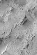
This Mars Global Surveyor (MGS) Mars Orbiter Camera (MOC) image shows the results of a process that is underway in the Memnonia uplands near 12.9°S, 152.7°W, to strip away one layer of material and reveal a formerly-buried landscape from beneath. All of the area shown here was once covered by a material that has been eroded by wind to form the sharp-crested, nearly-parallel ridges that run diagonally from the upper left toward lower right in this image. These ridges are a classic wind erosion form, known as a yardang. The image covers an area about 3 km (1.9 mi) wide and is illuminated by sunlight from the left/upper left.


