


Earth Gallery
Catalog of images, videos, and animations of Earth.

Latest Earth Content
Stay up-to-date with the latest content about the Earth from Photojournal
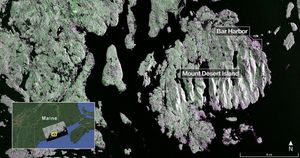
Captured on Aug. 21, 2025, this image from NISAR's L-band radar shows Maine's Mount Desert Island.
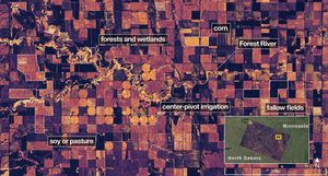
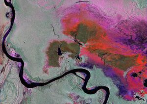
On Aug. 23, 2025, NISAR imaged land adjacent to northeastern North Dakota's Forest River.

NASA's Psyche spacecraft captured images of Earth and our Moon from about 180 million miles (290 kilometers) away in July…

The SWOT satellite caught the leading edge of the tsunami wave that rolled through the Pacific Ocean on July 30,…
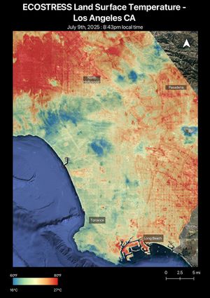
A short-lived heat wave that hit the Los Angeles area the week of July 7, 2025, was the first of…
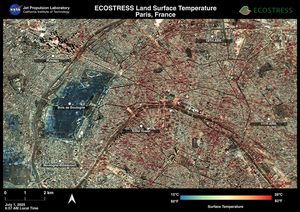
Data from NASA's ECOSTRESS instrument aboard the International Space Station shows Paris was one of many European cities hit by…
NISAR will track wetland flooding to study how these carbon-rich ecosystems are reacting to climate change. It will generate images…
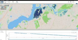
NASA, along with the Jet Propulsion Laboratory, is collaborating with the Alaska Satellite Facility to create a powerful web-based tool…
NASA's Terra spacecraft shows Magee Marsh Wildlife Area, located in northwest Ohio along the shores of Lake Erie.
NASA's Terra spacecraft shows Mackinac Island, Michigan, a small island off the northern coast of Lake Huron.
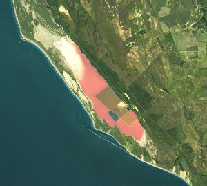
NASA's Terra spacecraft shows Hutt Lagoon, an elongate lake, located in a dune swale adjacent to the coast of the…
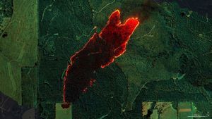
At one of the Mount Vernon, Alabama, fires, firefighters used AVIRIS-3 maps to determine where to establish fire breaks beyond…
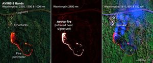
As firefighters worked to prevent a wildfire near Perdido, Alabama, they saw in an infrared fire map from NASA's AVIRIS-3…
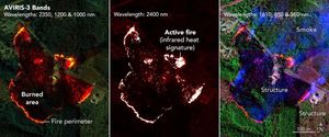
NASA's AVIRIS-3 airborne imaging spectrometer was used to map a wildfire near Castleberry, Alabama, on March 19, 2025. Within minutes,…
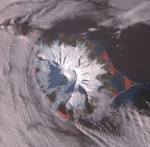
NASA's Terra spacecraft shows Heard, a remote volcanic island located in the southern Indian Ocean. It is an Australian Territory.
NASA's Terra spacecraft shows Runnymede meadow, a short drive from Windsor, England, west of London, near the Thames.
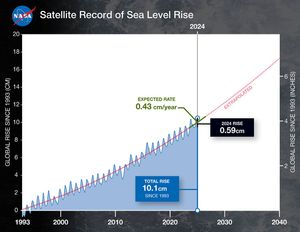
This graph shows global mean sea level (in blue) since 1993 as measured by a series of five satellites. The…
NASA's Terra spacecraft shows Charleston, the largest city in South Carolina, with almost 1 million people.

NASA's Terra spacecraft shows Taal Volcano in the Philippines, about 50 km south of Manila. It is the second most…

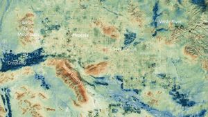
NASA's Terra spacecraft shows Nevada's only lithium-producing site, in Clayton Valley, Nevada.

Researchers from NASA's Jet Propulsion Laboratory and the National Oceanic and Atmospheric Administration (NOAA) analyzed vertical land motion along the…

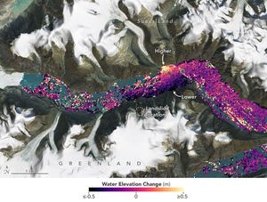
Researchers at NASA's Jet Propulsion Laboratory used data from an airborne radar to measure the movement of the slow-moving landslides…

NASA's Terra spacecraft shows the continuing eruption of Kilauea volcano, Hawaii, on January 18.

NASA's Terra spacecraft shows Mayotte, a volcanic island in the Comoros archipelago between the eastern coast of Africa and the…

NASA's Terra spacecraft shows Barra Island Eoligarry Airport, located in the Outer Hebrides, Scotland, U.K.
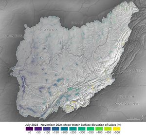
Data from the SWOT satellite was used to calculate average water levels for lakes and reservoirs in the Ohio River…

Saltwater intrusion will affect groundwater in about three of every four coastal aquifers around the world by the year 2100,…

NASA's Terra spacecraft shows Craters of the Moon National Monument, located in southern Idaho in the Snake River Plain.

NASA's Terra spacecraft shows the Eastern Black Sea region on the slopes of the Pontic mountain range, in Turkey.

Perched on the International Space Station, NASA's EMIT can differentiate between types of vegetation to help researchers understand the distribution…

NASA's EMIT collected this hyperspectral image of the Amazon River in northern Brazil on June 30, 2024, as part of…

NASA's Terra spacecraft shows Nyamulagira volcano, in the Democratic Republic of Congo, continuing eruptive activity since July 2024.
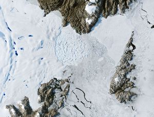
A SWOT data visualization shows high water levels on the northern side of Greenland's Dickson Fjord on Sept. 17, 2023.…

NASA's Cold Operable Lunar Deployable Arm (COLDArm) robotic arm system reaches out from a lander on the Moon and scoops…

NASA's Terra spacecraft shows the Klamath River in California and Oregon.

NASA's Terra spacecraft shows the Humboldt, or La Corona, Glacier in the Andes, Venezuela.

These holes, captured on Alaska's Matanuska Glacier in July 2012, are formed by cryoconite – dust particles that melt into…

On Sept. 19, 2024, the imaging spectrometer on the Carbon Mapper Coalition's Tanager-1 satellite detected this methane plume in Karachi,…

A data visualization shows the average concentration of PM2.5 particulate pollution in the Los Angeles region from 2000 to 2018,…
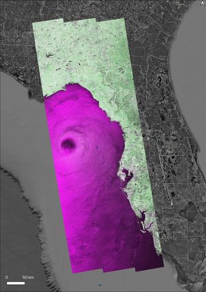
NASA's OPERA project generated a radar image of Hurricane Helene on Friday, Sept. 26, 2024, at 7:38 p.m. local time,…
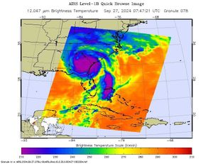
NASA's Atmospheric Infrared Sounder (AIRS) captured an infrared image of Hurricane Helene on Friday, Sept. 27, 2024, at 3:47 a.m.…

NASA's Terra spacecraft shows the Araxa mine in southern Brazil which produces more than 80% of the world's Niobium.

An imaging spectrometer designed by NASA's Jet Propulsion Laboratory captured its first data over Karachi, Pakistan, on Sept. 19, 2024.

Data from NASA's ECOSTRESS instrument aboard the International Space Station shows three wildfires burning in the mountains east and southeast…

NASA's Terra spacecraft shows the mausoleum of Qin Shi Huang, the first emperor of China. The terracotta army, was buried…

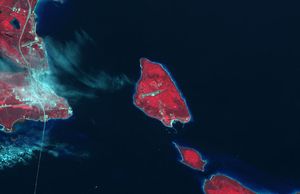
NASA's Terra spacecraft shows Tofua Island, in the central part of the Tonga Islands group, the summit of a large…

NASA's Terra spacecraft shows Mount Mabu in northern Mozambique, famous for its old-growth rain forest.

The location of Earth's spin axis moved about 30 feet (10 meters) between 1900 and 2023, as shown in this…
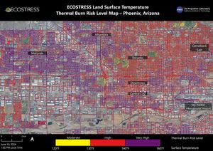
NASA's ECOSTRESS instrument on June 19 recorded scorching roads and sidewalks across Phoenix where contact with skin could cause serious…

NASA's Terra spacecraft shows the small island of Handa, off Scotland's northwest coast.

NASA's Terra spacecraft shows an eruption that began on March 2, 2024 at Fernandina Volcano, Galapagos.

NASA's Terra spacecraft shows Salin-de-Giraud, a major center of salt production on the right bank of the Rhone River in…

One of the two shoebox-size CubeSats that make up NASA's PREFIRE mission sits on a table at Blue Canyon Technologies.…

This artist's concept depicts one of two PREFIRE CubeSats in orbit around Earth. The NASA mission will measure the amount…
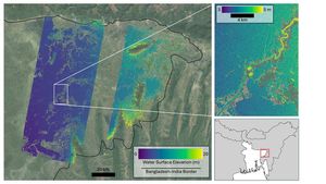
Flooding from monsoon rains covers a wide region of northeast Bangladesh in this Oct. 8, 2023, image showing data from…

NASA's Terra spacecraft shows Dinosaur Provincial Park, a UNESCO World Heritage Site east of Calgary, Alberta, Canada.

NASA's Terra spacecraft shows Ulaanbaatar, the capital of Mongolia and home to over half the country's population of about 3…

A NASA-led study combined stream-gauge measurements with computer models of 3 million river segments to create a global picture of…
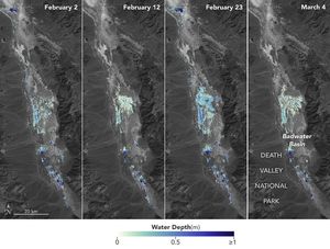
Water depths in Death Valley's temporary lake ranged between about 3 feet (or 1 meter, shown in dark blue) to…

NASA's Terra spacecraft shows the March 16, 2024, volcanic eruption in Iceland's Reykjanes Peninsula.

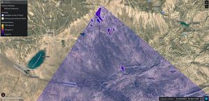
NASA's Terra spacecraft shows some of the tallest star dunes (or pyramid dunes), over 100 meters high, located in the…
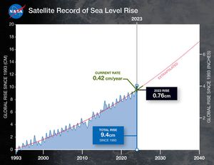
This graph shows global mean sea level (in blue) since 1993. The solid red line indicates the trajectory of this…

NASA's Terra spacecraft shows the small town of Orce in the heart of the high plateau of Grenada in southern…
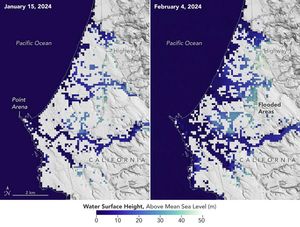
This image shows SWOT satellite data for water surface height in part of Mendocino County, Northern California, on Jan. 15,…

NASA's Terra spacecraft shows Smith Island, located in the Gulf of California, just off the eastern shore of Mexico's Baja…

NASA's Terra spacecraft shows volcanic activity near the town of Grindavik, Iceland on January 14, 2024.

NASA's Terra spacecraft shows Rupganj, Bangladesh, one of the top 3 fastest growing cities in the world between 2000 and…
Zachariae Isstrom, a glacier in northeast Greenland, retreated significantly between 1999 and 2022. A recent study found that it lost…
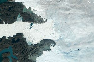
Jakobshavn Isbrae, a glacier on Greenland's western coast, retreated significantly between 1985 and 2022, losing about 97 billion tons (88…

NASA's Terra spacecraft shows the Rinjani Caldera in Indonesia.

Engineers and technicians prepare NASA's COLDArm robotic arm system for testing in a thermal vacuum chamber at the agency's Jet…

NASA's Terra spacecraft shows Badwater Basin in Death Valley, California, after Hurricane Hilary (August, 2023) dropped a year's worth of…

NASA's EMIT produced its first global maps of hematite, goethite, and kaolinite in Earth's dry regions using data from the…
EMIT identified a cluster of 12 methane plumes within a 150-square-mile (400-square-kilometer) area of southern Uzbekistan on Sept. 1, 2022.…
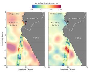
Data from the SWOT satellite shows sea level anomalies off the coast of Ecuador and Peru on Aug. 12, 2023,…

NASA's Terra spacecraft shows a severe drought in the Amazon is disrupting transportation, isolating communities and putting wildlife at risk.
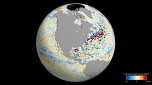
This animation shows global sea level data collected by the Surface Water and Ocean Topography satellite from July 26 to…

This composite uses data from two Japanese L-band SAR missions to reveal land-cover change in Brazil's Xingu River basin between…
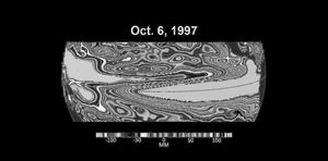
The maps in the animation show sea levels in the Pacific Ocean during early October of 1997, 2015, and 2023,…

NASA's Terra spacecraft shows Mar Menor, in southeast Spain. It is Europe's largest coastal saltwater lagoon.
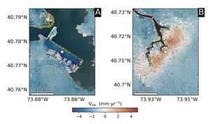
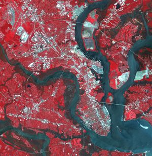
The team pinpointed hot spots: runway 13/31 at LaGuardia Airport in Queens, is subsiding at a rate of about 0.15…
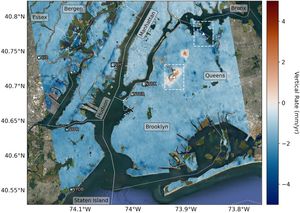
Mapping vertical land motion across the New York City area, researchers found the land sinking by about 0.06 inches (1.6…
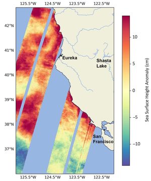
This data visualization shows sea surface heights off the northern California coast in August, 2023, as measured by the SWOT…

NASA's Terra spacecraft shows the Channeled Scablands in Washington, formed about 19,000 years ago when glacial Lake Missoula in Montana…

The mighty Yukon River and nearby lakes appear in red in this image produced using data recorded on June 18,…
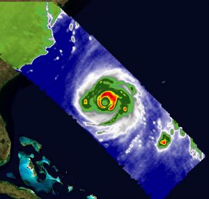
A pair of weather instruments built at NASA's Jet Propulsion Laboratory in Southern California captured images of Hurricane Franklin as…
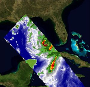
A pair of weather instruments built at NASA's Jet Propulsion Laboratory in Southern California captured images of Hurricane Idalia as…
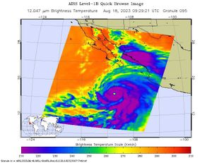
NASA's Atmospheric Infrared Sounder (AIRS) captured Hurricane Hilary on the morning of Aug. 18, 2023, when it was a Category…

NASA's Terra spacecraft shows areas of deforestation, surrounded by bright green areas of tropical vegetation, in southeast Sulawesi, Indonesia. The…
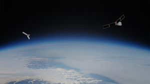
The PREFIRE mission will send two CubeSats – shown as an artist's concept against an image of Earth from orbit…

NASA's Terra spacecraft shows the eruption of Hunga Tonga-Hunga Ha'apai in 2022. It produced a plume 58 km high, the…
Amid a record heat wave in July, the Phoenix area saw surfaces such as roads and buildings stay hot long…

NASA's Terra spacecraft shows the Democratic Republic of Sao Tome and Principe, an island country in the Gulf of Guinea,…

The Surface Water and Ocean Topography (SWOT) mission collected data on sea levels around two of the inhabited islands of…

NASA's Terra spacecraft shows folded sedimentary rocks which are part of the Greater Caucasus Mountain Belt in Iran, near the…

NASA's Terra spacecraft shows the world's largest cemetery, Wadi-al-Salam, located in the holy city of Najaf, Iraq, west of the…

NASA's Terra spacecraft shows shade covering shelter farmed ginseng from the effects of direct sunlight in Heilongjiang province, northeast China.

A March 2023 study by JPL researchers compared methane emissions in 2020, early in the COVID-19 pandemic, to emissions measured…

A February 2023 study by JPL researchers estimated that annual methane emissions in the Los Angeles Basin fell by about…
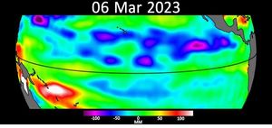
This animation shows Kelvin waves moving across the equatorial Pacific Ocean from west to east during March and April, 2023.…


