


![Request for Information – Potential [Placeholder for Prize]](https://assets.science.nasa.gov/dynamicimage/assets/science/psd/solar/2023/09/s/solarsystem_0.jpg?w=1024)


Description
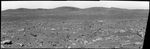
This mosaic image from the Mars Exploration Rover Spirit panoramic camera shows the view acquired after the rover drove 50.2 meters (165 feet) on the martian afternoon of sol 89 (April 3, 2004). The view shows the direction of the rover's future drive destination. In the distance are the eastern-lying "Columbia Hills." This image was assembled from images in the panoramic camera's green (530 nanometer) filter.
Anatolia was named after the Anatolian fault system in Turkey.


