


Description
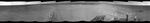
The component images for this 360-degree panorama were taken by the navigation camera on NASA's Mars Exploration Rover Opportunity after the rover drove about 97 feet (29.5 meters) during the mission's 3,642nd Martian day, or sol (April 22, 2014). The rover drove southwestward that sol, so the tracks from this end-of-drive position recede toward the northeast. For scale, the distance between the two parallel tracks is about 3.3 feet (1 meter).
The position is just west of the ridgeline of the west rim of Endeavour Crater.
A stereo anaglyph of this image is available at https://photojournal.jpl.nasa.gov/catalog/PIA18099.
JPL manages the Mars Exploration Rover Project for NASA's Science Mission Directorate in Washington. For more information about Spirit and Opportunity, visit http://marsrovers.jpl.nasa.gov.


