


.png?w=1024)


Description
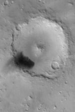
MGS MOC Release No. MOC2-450, 12 August 2003
The Mars Global Surveyor (MGS) Mars Orbiter Camera (MOC) wide angle red instrument captured this autumn view of Peridier Crater on August 6, 2003. The crater is about 100 km (62 mi.) in diameter and located at 25.7°N, 276.2°W. It was named for French astronomer Julien Peridier (1882-1967). In this Mercator map-projected view, north is up and east is to the right. The dark feature on the southwest floor of the crater is known from high resolution MOC images to be a field of windblown dunes. Finer, dark-toned sediment has been blown out of the dune field and settled on the crater rim and just outside the crater to the southwest. Sunlight illuminates the scene from the lower left.


