


Description
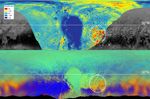
These maps are from New Horizons' data on the topography (top) and composition (bottom) of Pluto's surface. In the high-resolution topographical map, the highlighted red region is high in elevation. The map below, showing the composition, indicates the same section also contains methane, color-coded in orange. One can see the orange features spread into the fuzzier, lower-resolution data that covers the rest of the globe, meaning those areas, too, are high in methane, and therefore likely to be high in elevation.
The Johns Hopkins University Applied Physics Laboratory in Laurel, Maryland, designed, built, and operates the New Horizons spacecraft, and manages the mission for NASA's Science Mission Directorate. The Southwest Research Institute, based in San Antonio, leads the science team, payload operations and encounter science planning. New Horizons is part of the New Frontiers Program managed by NASA's Marshall Space Flight Center in Huntsville, Alabama.


