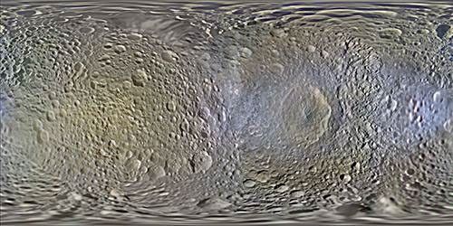
Color Map of Mimas (2014)
| PIA Number | PIA18437 |
|---|---|
| Language |
|
This global color mosaic of Saturn's moon Mimas was produced from images taken by NASA's Cassini spacecraft during its first 10 years exploring the Saturn system. These are the first global color maps of these moons produced from the Cassini data.
The colors shown in these global mosaics are enhanced, or broader, relative to human vision, extending into the ultraviolet and infrared range.
Apart from the moon's enormous impact crater, named Herschel, a dramatic feature on these maps is the equatorial band on Mimas' leading hemisphere. Cassini found this band to be significantly brighter in the ultraviolet than surrounding terrains, and it appears somewhat bluish here. This feature, similar to one on Tethys, was found to correlate with the predicted pattern of bombardment of the moons' surfaces by high-energy electrons trapped in Saturn's magnetic field. This bombardment is thought to alter the surface ices on a crystalline scale and change their color. Later thermal observations by Cassini's Composite Infrared Spectrometer (CIRS) instrument showed that these features also form thermal anomalies on the surface, giving rise to the nickname "Pac-Man" features (see A Pair of 'Pac-Men').
Resolution on Mimas in the maps is 200 meters per pixel.
Image selection, radiometric calibration, geographic registration and photometric correction, as well as mosaic selection and assembly were performed by Paul Schenk at the Lunar and Planetary Institute. Original image planning and targeting for Saturn's icy moons were performed by Tilman Denk (Frei Universitat, Berlin) and Paul Helfenstein (Cornell University, Ithaca, New York).
Credit: NASA/JPL-Caltech/Space Science Institute/Lunar and Planetary Institute


