Manam Volcano

MANAM VOLCANO: Manam Volcano in Papua New Guinea, as seen from space on June 16, 2010. Located 13 kilometers (8 miles) off the coast of mainland Papua New Guinea, Manam forms an island 10 kilometers (6 miles) wide. It is a stratovolcano. The volcano has two summit craters, and although both are active, most historical eruptions have arisen from the southern crater.On June 16, the volcano released a thin, faint plume as clouds clustered at the volcano's summit. Rivulets of brown rock interrupt the carpet of green vegetation on the volcano’s slopes. White clouds partially obscure the satellite’s view of Manam. The clouds may be the result of water vapor from the volcano, but they may also have formed independently of volcanic activity. The volcanic plume appears as a thin blue-gray veil extending toward the northwest over the Bismarck Sea.
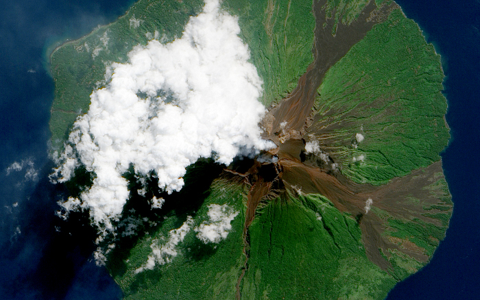
NASA image acquired June 16, 2010. Papua New Guinea’s Manam Volcano released a thin, faint plume on June 16, 2010, as clouds clustered at the volcano’s summit. The Advanced Land Imager (ALI) on NASA’s Earth Observing-1 (EO-1) satellite took this picture the same day. Rivulets of brown rock interrupt the carpet of green vegetation on the volcano’s slopes. Opaque white clouds partially obscure the satellite’s view of Manam. The clouds may result from water vapor from the volcano, but may also have formed independent of volcanic activity. The volcanic plume appears as a thin, blue-gray veil extending toward the northwest over the Bismarck Sea. Located 13 kilometers (8 miles) off the coast of mainland Papua New Guinea, Manam forms an island 10 kilometers (6 miles) wide. It is a stratovolcano. The volcano has two summit craters, and although both are active, most historical eruptions have arisen from the southern crater. NASA Earth Observatory image created by Jesse Allen, using EO-1 ALI data provided courtesy of the NASA EO-1 team. Caption by Michon Scott. Instrument: EO-1 - ALI
January 5, 2012
CreditImage taken by the Advanced Land Imager (ALI) on NASA’s Earth Observing-1 (EO-1) satellite. Source: NASA's Earth Observatory website. Image created by Jesse Allen and caption by Michon Scott.
Language
  • english

Manam Volcano in Papua New Guinea, as seen from space on June 16, 2010. Located 13 kilometers (8 miles) off the coast of mainland Papua New Guinea, Manam forms an island 10 kilometers (6 miles) wide. It is a stratovolcano. The volcano has two summit craters, and although both are active, most historical eruptions have arisen from the southern crater.

On June 16, the volcano released a thin, faint plume as clouds clustered at the volcano's summit. Rivulets of brown rock interrupt the carpet of green vegetation on the volcano’s slopes. White clouds partially obscure the satellite’s view of Manam. The clouds may be the result of water vapor from the volcano, but they may also have formed independently of volcanic activity. The volcanic plume appears as a thin blue-gray veil extending toward the northwest over the Bismarck Sea.