Aircraft Sensors
Filters

As wildland fires raged in the American West, NASA airborne technology was there to image it in incredible detail.

NASA airborne technology revealed the progression of a controlled fire at Fort Stewart-Hunter Army Airfield.

Detailed fire maps, produced in minutes with data from a NASA airborne sensor, enabled firefighters in Alabama to limit the…

NASA radar imagery revealed that the active area of a decades-old landslide has grown following periods of heavy rainfall in…

A NASA airborne instrument captured images of the fire’s aftermath in and around Altadena.

The iconic trees and shrubs of the Florida Everglades are under increased stress due to more frequent, intense hurricanes.

A novel radar image reveals structural elements of Camp Century, an abandoned U.S. military base buried within the Greenland Ice…

After a brutally hot summer in 2023 that caused widespread bleaching and coral death, summer 2024 was more favorable for…
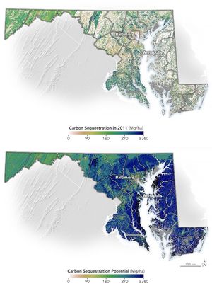
Using remote sensing, researchers have developed a method to guide the state of Maryland’s tree-planting efforts.