UAVSAR
Filters

NASA radar imagery revealed that the active area of a decades-old landslide has grown following periods of heavy rainfall in…

A novel radar image reveals structural elements of Camp Century, an abandoned U.S. military base buried within the Greenland Ice…
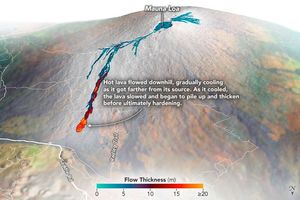
Airborne mapping of the thickness of the lava flows helped scientists calculate that 230 million cubic meters of molten rock…
Scientists are using radar data to decipher where and how well landscapes recover in the years after major fires.

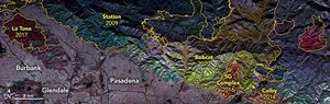
Through the study of an unusual, long-lasting slide, has developed a new technique to make prediction easier and more accurate.

“Stable landslide” sounds like a contradiction in terms, but there are indeed places on Earth where land has been creeping…

Through a combination of airborne radar and ground-based GPS, a research team has developed detailed models of how much land…

Plane-mounted radar and other instruments are studying the shrinking and growing wetlands along the Gulf Coast.

An airborne radar instrument allows scientists to ascertain the shape of a Colombian volcano. Future measurements will help detect how…