![Request for Information – Potential [Placeholder for Prize]](https://assets.science.nasa.gov/dynamicimage/assets/science/psd/solar/2023/09/s/solarsystem_0.jpg?w=1024)


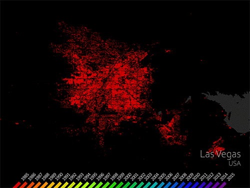
Urban Growth
Filters

The Landsat satellite program, with its unparalleled 53-year historic record, can reveal changes through the Annual National Land Cover Database…
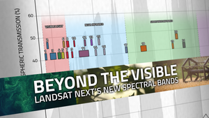
With Landsat Next’s 26 new spectral bands, we’ll be able to see our planet like never before. Landsat Next’s enhanced…

More water is taken from the Colorado River than it has to give. Better water use accounting made possible by…

Over the past few years, machine learning techniques have been increasingly used to analyze the vast amount of data collected…

A new analysis found that between 34,000-38,000 could have been reduced with local increases in green vegetation in US metropolitan…
The World Settlement Footprint is the world’s most comprehensive dataset on human settlement.

Study of two metro areas finds where parks, trees and other green spaces are located.

Landsat-based urban extent and phenology indicators provide new information about urban environments.

Socio-economically vulnerable populations are at a higher risk of experiencing urban heat effects.