C-SAR Sensor
Filters
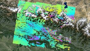
NASA’s ARIA Project Maps Deformation of Earth’s Surface from Nepal Quake
2 min read
This deformation map from NASA's ARIA project shows surface displacements around Kathmandu, the April 25, 2015, magnitude 7.8 Gorkha earthquake…
May 2, 2015
Article
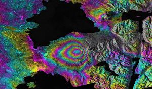
Ground Deformation from Chilean Volcanic Eruption Shown by Satellite Radar Image
1 min read
This satellite interferometric synthetic aperture radar image-pair shows relative deformation of the Earth's surface when nn April 22-23, 2015, significant…
Apr 29, 2015
Article