![Request for Information – Potential [Placeholder for Prize]](https://assets.science.nasa.gov/dynamicimage/assets/science/missions/a-step/FFR_Earth_Background_20251120%20.png?w=1024)


wildfires
Filters

ECOSTRESS, NASA's Earth-observing mission, detected three wildfires burning in the western US on July 28, 2018, the Carr and Whaleback…

NASA's Terra satellite took these images of the Carr Fire (left) and the Ferguson Fire (right) on July 27 and…

On April 30, 2018, NASA's Multi-angle Imaging SpectroRadiometer (MISR) captured imagery of the plume top over the active Tinder Fire…

On Dec 26, 2017, NASA's Terra acquired this image of The Thomas Fire, the largest wildfire in California's recorded history.…
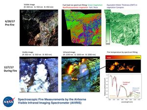
NASA's Airborne Visible Infrared Imaging Spectrometer instrument onboard an ER-2 aircraft observed wildfires burning in Southern California on Dec. 5-7,…

The ARIA team at NASA's JPL created this Damage Proxy Map depicting areas in Southern California that are likely damaged…
NASA's Terra satellite passed directly over the island of Madeira on Wednesday, Aug. 10, 2016, where a wildfire spread to…

NASA's Terra spacecraft captured this image of the Sand Fire in Southern California. The satellite passed over the region on…

This image, captured by NASA's Terra spacecraft in July, 2016, shows the Sand fire, in the mountains northwest of Los…