PROJECT
Hyper-Angular Rainbow Polarimeter (HARP)
SNAPSHOT
HARP aims to help identify air pollution, aerosols and clouds.
The Hyper-Angular Rainbow Polarimeter’s measurements help us better understand how clouds and aerosols impact weather, climate, and air quality.
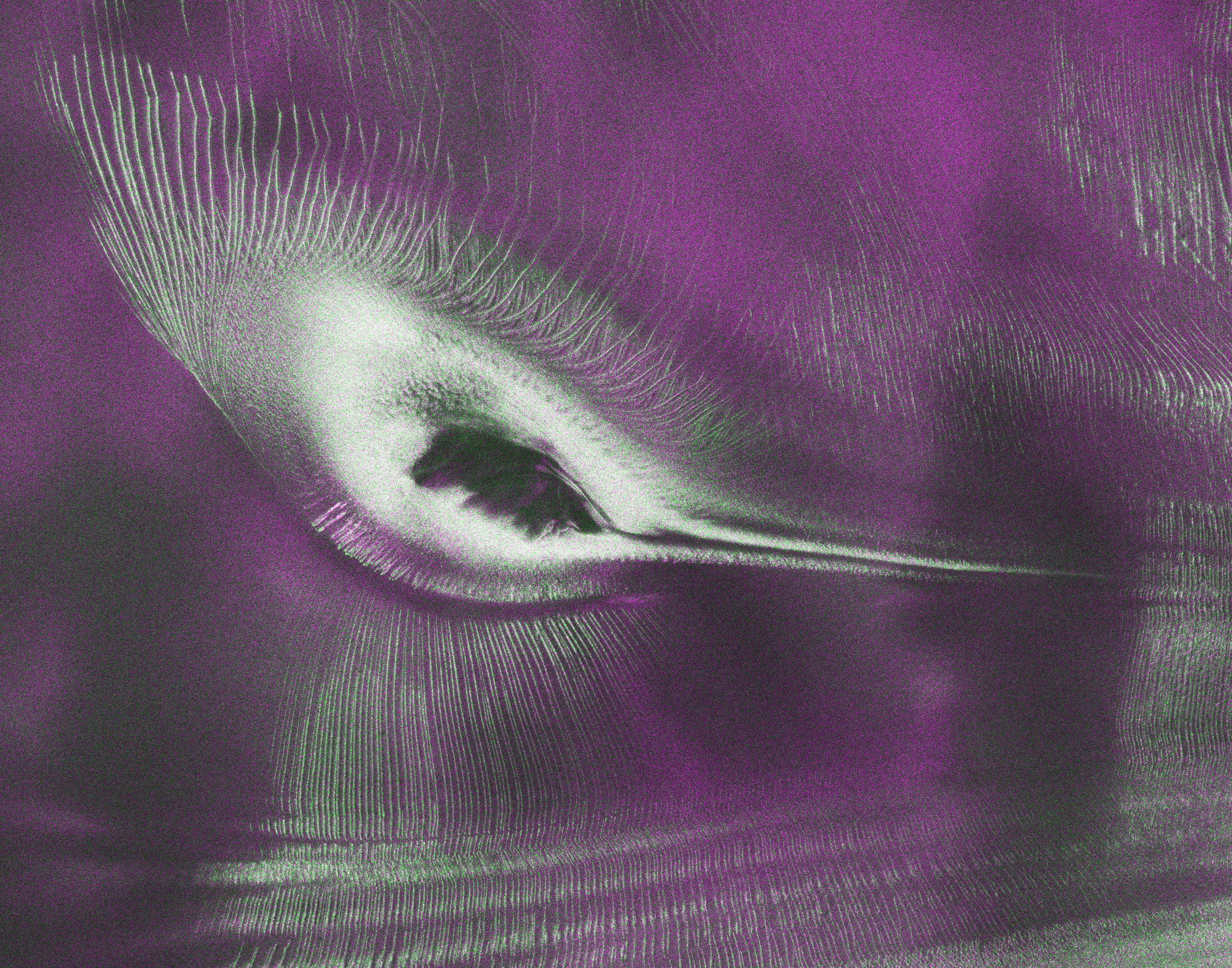
The Hyper-Angular Rainbow Polarimeter (HARP) CubeSat achieved “first light” on April 16, 2020. The tiny satellite sent back its very first image over Europe with bright splashes of colors labeling clouds and aerosols, tiny particles in the atmosphere.
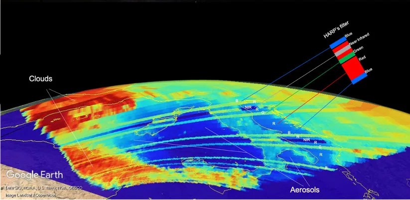
HARP filters light into four wavelengths and uses a prism to rotate that light to three polarization angles. Just as polarized sunglasses help block bright light to help you see when it’s sunny, HARP can block certain wavelengths and make observations from many angles. Its images reveal what is hidden to the naked eye: amounts and types of aerosols as well as the size of water droplets and ice particles inside clouds.
“Every time HARP flies over a region, we see that region from multiple perspectives,” Vanderlei Martins, the Principal Investigator for HARP and a professor at the University of Maryland, Baltimore County, said. HARP launched from NASA’s Wallops Flight Facility on November 2, 2019. Three months later, in February 2020, the CubeSat floated away from the Space Station and began its orbit around Earth.
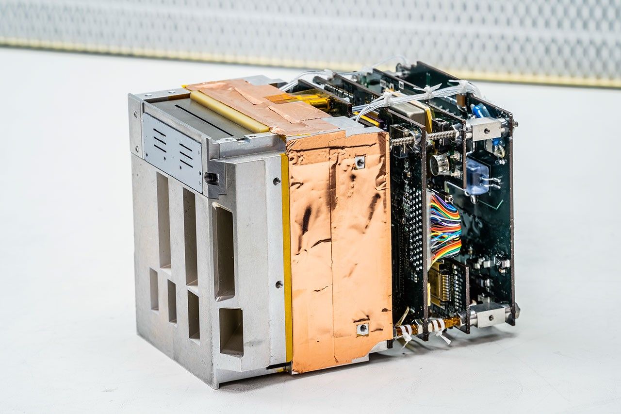
HARP marks NASA’s first attempt to put a polarimeter, which measures the polarization of light, aboard a CubeSat. Developed with funds from the Earth Science Division’s In-Space Validation of Earth Science Technologies (InVEST) Program, HARP could pave the way for future NASA missions involving a constellation of little satellites peering down at clouds and aerosols, Martins said. Martins is a physics professor at the University of Maryland, Baltimore County and is affiliated with Goddard through the Joint Center for Earth Systems Technology. He worked with Goddard colleagues to develop HARP.
“HARP, as the first multiangle wide field-of-view cloud-aerosol CubeSat mission, is a great example of how a creative and innovative team can advance new technologies for atmospheric science observations,” said Charles Norton, special advisor for small spacecraft missions at NASA Headquarters in Washington.
Chasing clouds and aerosols with rainbows
Martins breathed a sigh of relief when his team first made contact with the tiny satellite in March 2020. “Since you cannot go there and touch it, you try to get as much information as you can in a ten-ish minute timeframe as the satellite passes over the Wallops ground station,” Martins said. HARP sent back a simple one-frame image to let its team know it was working.
“However, it’s the next one that’s really exciting,” Martins said. That “next one” arrived on April 15 and combined 400 frames into one image. “As we include hundreds of frames into one image, we can start to do exciting science,” Martins said.
“HARP will be able to provide much more information about the microphysical properties of aerosols than was previously available,” said Henrique Barbosa, a professor and scientist with the University of São Paulo in São Paulo, Brazil, who is collaborating with Martins on HARP and other projects.
The team must strategically determine when HARP will collect data because it’s a CubeSat with limited power and data capabilities, Barbosa said. For instance, he would like to have it collect data over the Amazon to learn more about the impact of the 2019 Brazilian Amazon rainforest fires, which were much larger and more intense than in previous years.
Smoke from the Amazon fires includes soot and aerosols, which can all impact weather and climate. Aerosols from burning biomass to clear land are smaller than natural aerosols. With HARP, scientists can determine whether clouds have smaller, pollution-driven droplets, or larger, naturally derived droplets. HARP’s data can also be combined with ground-based observations and experiments to better extrapolate those results and reveal aerosol processes across a wider region, Barbosa said.
The three HARPs
Martins may have started with the idea for HARP as a CubeSat, but before the tiny satellite could launch, it had two siblings: AirHARP and HARP2.
AirHARP used the same polarimeter technology as HARP but flew aboard two aircraft rather than a satellite in 2017. AirHARP was part of the Lake Michigan Ozone Measurements campaign, which involved a NASA UC12 plane, and the NASA Aerosol Characterization from Polarimeter and Lidar campaign, which obtained aerosol and clouds measurements over the U.S. from the NASA high-altitude ER-2 aircraft.
“We were able to simulate what HARP would do from space,” Barbosa said of AirHARP’s flights. The airborne version helped Barbosa and Martins develop procedures and algorithms that will eventually help download and digest HARP’s data.
However, unlike AirHARP, which was on a set flight path, HARP cannot be controlled once in space. “Once the CubeSat leaves the space station, its course is whatever it will be, and that’s it,” Barbosa said. Once scientists on the ground make contact with the orbiting HARP, they can predict its orbit and turn it on and off when they want to take a measurement over a particular region, but they can’t alter its course.
HARP2, on the other hand, will be a much more powerful version of HARP. HARP2 will fly with NASA’s Plankton, Aerosol, Cloud, ocean Ecosystem (PACE) mission, which is currently under development and plans to improve NASA’s over 20-year record of satellite observations of global ocean biology, aerosols and clouds. Since PACE is a much larger spacecraft with more power capabilities and a much larger team behind it, HARP2 will be able to operate all the time and collect significantly more science data than HARP.
“The HARP CubeSat has perfect timing,” Martins said. “We will use HARP’s data to prepare for HARP2,” he continued.
PROJECT LEAD
Vanderlei Martins, University of Maryland, Baltimore County
SPONSORING ORGANIZATION
Earth Science Division’s In-Space Validation of Earth Science Technologies (InVEST) Program