PROJECT
Supporting Shellfish Aquaculture in the Chesapeake Using Artificial Intelligence
SNAPSHOT
A NASA team is training and verifying machine learning algorithms that will be used to identify areas of poor water quality in satellite images—starting with the Chesapeake Bay.
Excess nutrients and pollutants washed off land by rainstorms can degrade water quality and harm marine life and humans. Identifying these problems before they can affect us is a constant challenge for water resource managers.
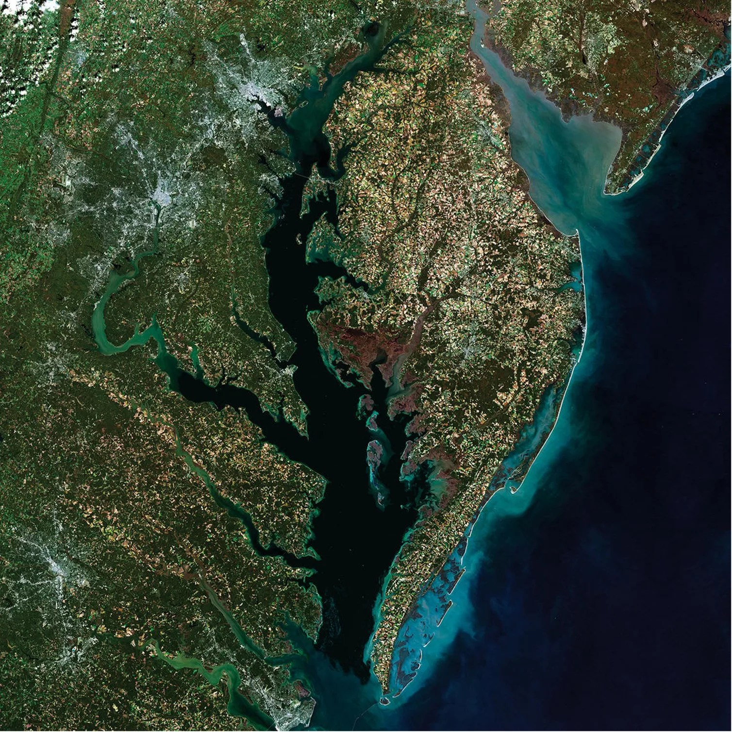
NASA, the National Oceanic and Atmospheric Administration (NOAA), and the Maryland Department of the Environment (MDE) are teaming up to create a software program to help identify impaired water quality more easily. The software is being designed to aid resource managers monitoring the Chesapeake Bay, which is home to a vibrant aquaculture industry that contributes more than $9 million annually to Maryland’s state economy, according to the Chesapeake Bay Foundation.
This collaboration between federal and state agencies – which provided an opportunity to leverage NASA sensors mounted to MDE boats and a US Coast Guard tower – began a complex software development process that includes collecting in-situ observations for training and verifying machine learning algorithms that will ultimately be used to identify areas of poor water quality in satellite images.
Though still in the early stages of development, the research team has already reached several important milestones. In particular, they demonstrated that their software is able to successfully train machine learning algorithms to identify precursors to poor water quality in satellite images over the Chesapeake Bay collected by NASA satellite MODIS-Aqua and the Sentinel 3 OLCI satellite, which is managed by the European Space Agency.
This software prepares scientists to maximize the utility of future missions – such as NASA’s upcoming Surface Biology and Geology (SBG) and Plankton, Aerosol, Cloud, ocean Ecosystem (PACE) missions – and to help coastal communities that depend on pollution-free seas for their livelihoods.
“Maryland and Virginia have decades of observational data, making the Chesapeake Bay the perfect place to develop and train our algorithms to find patterns too subtle for human eyes to detect on their own,” said Stephanie Schollaert Uz, project Principal Investigator and Applied Science Manager at NASA Goddard Space Flight Center.
Schollaert Uz explains that as climate change leads to wetter, more energetic storms, a larger amount of nutrients, sediments, and pollutants like raw sewage will find their way from urban environments into the sea. The excess runoff not only jeopardizes the health of aquatic ecosystems, but also the health of human beings.
“For example, sewage leaks or spills can contaminate an entire crop of oysters, and if the problem goes undetected, people can get sick,” said Schollaert Uz.
Resource managers with the MDE work tirelessly to ensure the Chesapeake Bay is safe for aquaculture and recreation. But with hundreds of test sites to check each month, it’s difficult to find every instance of polluted water before it can endanger people and the environment.
NASA satellites, with their broad coverage and multiple looks within a month, could be an excellent tool for augmenting state water quality monitoring programs. But many pollutants don’t emit an optical signature that can be identified from satellite sensors, which use light to identify sediments, phytoplankton pigments, and dissolved organics. Instead, machine learning algorithms must detect secondary – or “proxy” – patterns indicative of invisible pollutants.
Troy Ames, project co-Investigator and Computer Engineer at NASA’s Goddard Space Flight Center, explains that their program is composed of several key components to train machine learning algorithms and look for evidence of poor water quality. These components include encoder modules for extracting important information from raw data sets, a fusion module to aggregate that information into a discernible pattern, a temporal module to detail the evolution of information over time, and decoder modules to translate that information into water quality indicators.
“This facilitates both training and testing, because you can actually combine components in different configurations based on indicators,” said Ames.
COVID-19 made it difficult for Schollaert Uz and her team to complete the in-person fieldwork and lab studies necessary for training their algorithms to identify runoff pollutants like sewage in satellite imagery. But they were able to use model output from the Virginia Institute of Marine Sciences Chesapeake Bay Environmental Forecast System to train machine learning techniques that assimilate satellite data to identify precursors to hypoxia, such as areas of low oxygen that can be devastating to aquatic ecosystems.
“I can’t emphasize enough how difficult it is to connect optical satellite imagery with hypoxia. Hypoxia happens at depth, not near the surface. This is a really complicated problem that regularly negatively impacts water quality,” said Schollaert Uz.
To develop their project further, Schollaert Uz and her colleagues intend to bolster their current machine learning method with environmental information from NOAA and further field observations, with the ultimate goal of exploiting upcoming hyperspectral satellite data in near-real time for Chesapeake Bay resource managers.
“NASA maintains an incredible collection of Earth science data. We want to help people access and apply that data to solve real-world problems,” said Schollaert Uz.
PROJECT LEAD
Stephanie Schollaert Uz, Applied Science Manager at NASA Goddard Space Flight Center
SPONSORING ORGANIZATION
Earth Science Division’s Advanced Information Systems Technology (AIST) Program