PROJECT
RainCube (Radar in a CubeSat)
KEY POINTS
RainCube successfully demonstrated Ka-band precipitation radar technology on a low-cost, quick-turnaround platform. This new technology will enable constellations of small spacecraft that can track storms and provide data about how the storms evolve in short time scales—capabilities that are needed to improve numerical weather and climate models.
Accurate prediction of severe storms yields numerous societal benefits—from predicting when and where disaster relief may be required, to helping you decide whether to take an umbrella when you leave your house. But to improve these predictions, scientists need a way to measure the movement of water and air in thunderstorms globally. RainCube has demonstrated a technology that will enable such measurements to be collected on a global scale in a cost-effective manner.
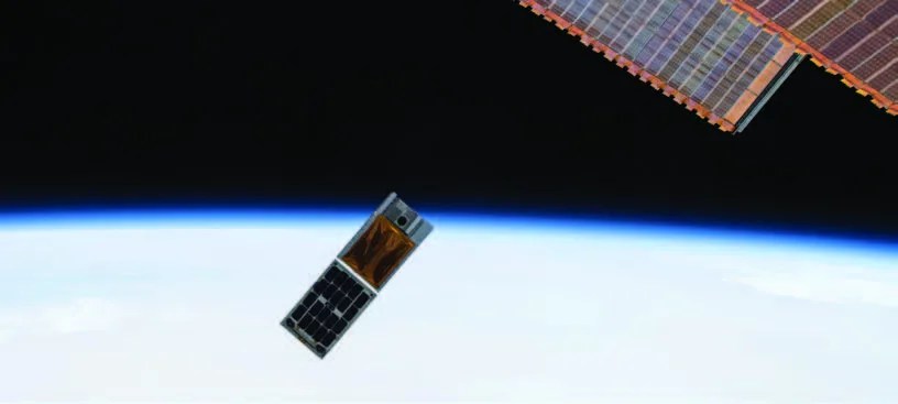
Developed at the NASA Jet Propulsion Laboratory (JPL), RainCube has demonstrated a new architecture for miniaturized Ka-band precipitation radars. Following a successful deployment from the International Space Station in July 2018, the RainCube radar was turned on in late August, and successfully acquired vertical range profiling measurements of precipitation and land surface at a nadir-pointing configuration. Since then, it has continued to acquire additional measurements, including the vertical precipitation profile of Typhoon Trami on September 28, 2018, shown on the previous page.
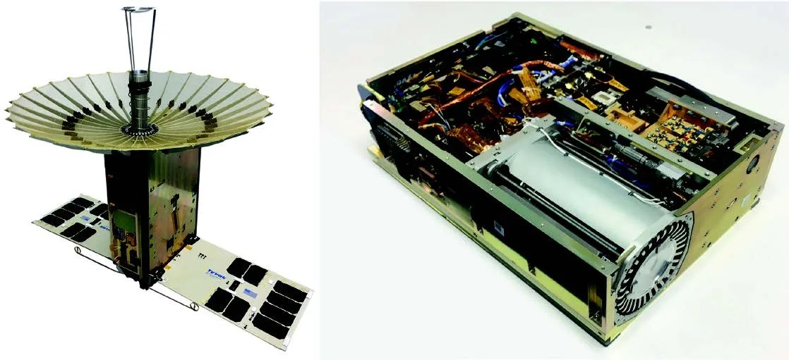
RainCube uses Ka-band radar to “see” into storms. The satellite sends a radar signal towards the storm being observed, and receives a signal back as the radar bounces off raindrops in the storm. This capability provides a picture of the activity inside the storm such that scientists can learn about the processes that make the storm grow or decay.
A network of ground-based weather radars provides much of the information currently used to produce weather forecasts. However, these systems have several limitations that prevent them from providing a global view of storm activity: only developed countries are capable of supporting such networks, measurements over oceans are largely unattainable, and many mountain ranges present significant challenges to these ground-based measurement systems. Weather satellites provide a global view, but can only capture images of the tops of the storms; they do not provide much of the information that is needed to understand what is happening inside the storms. A couple of spacecraft with downward-looking cloud or precipitation radars have enabled improved understanding of the structure and global distribution of storms, but these missions are usually expensive and thus it is cost-prohibitive to launch a constellation that would enable continuous global coverage.
“RainCube introduces a new paradigm to observe weather processes by enabling a constellation of precipitation-profiling radars, which would revolutionize climate science and weather forecasting.” - Dr. Eva Peral, NASA JPL
As PI Dr. Eva Peral notes, “RainCube introduces a new paradigm to observe weather processes by enabling a constellation of precipitation-profiling radars, which would revolutionize climate science and weather forecasting.” The RainCube radar takes measurements in a geometry similar to other existing spaceborne radars, but its novel architecture reduces power consumption, mass, volume, and the number of components by more than an order of magnitude with respect to those instruments. Thus, the RainCube architecture is compatible with the volume, mass, and power constraints of small satellites, significantly reducing the manufacturing cost. The RainCube mission ultimately demonstrates the potential for an entirely new and different way of observing Earth with a constellation of low-cost small radars. A constellation of “RainCube-like” spacecraft would provide the spatial and temporal coverage and sampling that are needed to improve our understanding of Earth’s water cycle and eventually advance the numerical models that are used for weather forecasting, enabling more accurate prediction of rain, snow, sleet, and hail.
SPONSORING ORGANIZATION
Earth Science Division’s InVEST Program
PROJECT LEAD
Dr. Eva Peral, NASA JPL