![Request for Information – Potential [Placeholder for Prize]](https://assets.science.nasa.gov/dynamicimage/assets/science/psd/solar/2023/09/s/solarsystem_0.jpg?w=1024)


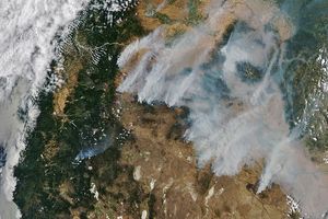
Dozens of fires were detected in the Adana region of Turkey on June 15, 2003, by the Moderate Resolution Imaging Spectroradiometer (MODIS) on the Terra satellite. The fires have been marked with red dots in this true-color image. The Adana region is a low-lying coastal area ringed by the Taurus Mountains to the north and the Nur Mountains, covered in green vegetation, to the east. Because this region is one of the most agriculturally productive in the whole country, it is likely these fires are being used in for agricultural activities such as land clearing. At bottom right is Syria.
The high-resolution image provided above is 500 meters per pixel. The MODIS Rapid Response System provides this image at MODIS’ maximum spatial resolution of 250 meters.
References & Resources
Image courtesy Jeff Schmaltz, MODIS Rapid Response Team, NASA GSFC