- Quicktime (.mov) format (650 KB)
- MPEG-1 (.mpg) format (1.3 MB)
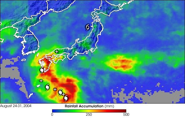
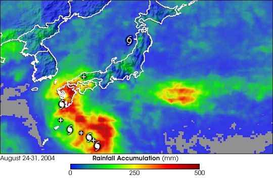
At one time, Chaba was a powerful super typhoon packing winds of 155 knots(178 mph) as it crossed the central Philippine Sea. The storm weakened asit turned northward and struck Kyushu, the southernmost main island ofJapan, on the 30th of August 2004 as a Category 2 Typhoon with sustainedwinds estimated at 85 knots (98 mph) by the Joint Typhoon Warning Center.The storm resulted in widespread flooding and was responsible for at least13 fatalities in Japan.
The Tropical Rainfall Measuring Mission (TRMM) satellite has been monitoringrainfall over the global tropics since its launch in November of 1997 usingboth a microwave imager and the first precipitation radar in space. TheTRMM-based, near-real time Multi-satellite Precipitation Analysis (MPA) atthe NASA Goddard Space Flight Center provides quantitative rainfall estimatesover the global tropics. MPA rainfall totals for the period 24 to 31 August2004 are shown for Japan and surrounding areas. Cyclone symbols are shown atthe 00:00 UTC positions, indicating the path taken by Chaba. A swath of veryhigh rainfall amounts in excess of 305 millimeters (red areas) is clearly visiblejust to the right of Chaba's track. Locally heavier amounts of up to near500 millimeters of rain are embedded within the high rain area. The swath of heavyrain extends over Kyushu where Chaba made landfall but then diminishesdramatically farther north as the storm rapidly accelerated away.
TRMM is a joint mission between NASA and the Japanese space agency JAXA.
References & Resources
NASA images produced by Hal Pierce (SSAI/NASA GSFC) and caption by Steve Lang (SSAI/NASA GSFC), NASA's Tropical Rainfall Measuring Mission.