![Request for Information – Potential [Placeholder for Prize]](https://assets.science.nasa.gov/dynamicimage/assets/science/missions/a-step/FFR_Earth_Background_20251120%20.png?w=1024)


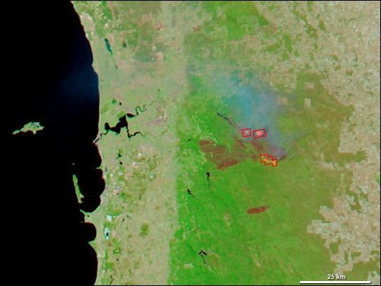
In the Darling Range Mountains on the outskirts of Perth in Western Australia, a large wildfire came under a tentative containment on January 20, 2005, but officials worried that hot, windy weather predicted for later that week would fan the flames of the 25,000-hectare blaze (61,776 acres, or 250 square kilometers) once again. This image of the large fire is made from satellite observations collected by the Moderate Resolution Imaging Spectroradiometer (MODIS) on NASA’s Aqua satellite. The image combines both visible and infrared wavelengths of light energy to bring out the land surface affected by burning. Vegetation is bright green, burned areas appear red, and water is deep blue to nearly black. The areas where MODIS detected actively burning fire are outlined in red. Within these red perimeters, intensely flaming fires glow in hot pink.
References & Resources
NASA image courtesy the MODIS Rapid Response Team, NASA-GSFC