![Request for Information – Potential [Placeholder for Prize]](https://assets.science.nasa.gov/dynamicimage/assets/science/psd/solar/2023/09/s/solarsystem_0.jpg?w=1024)


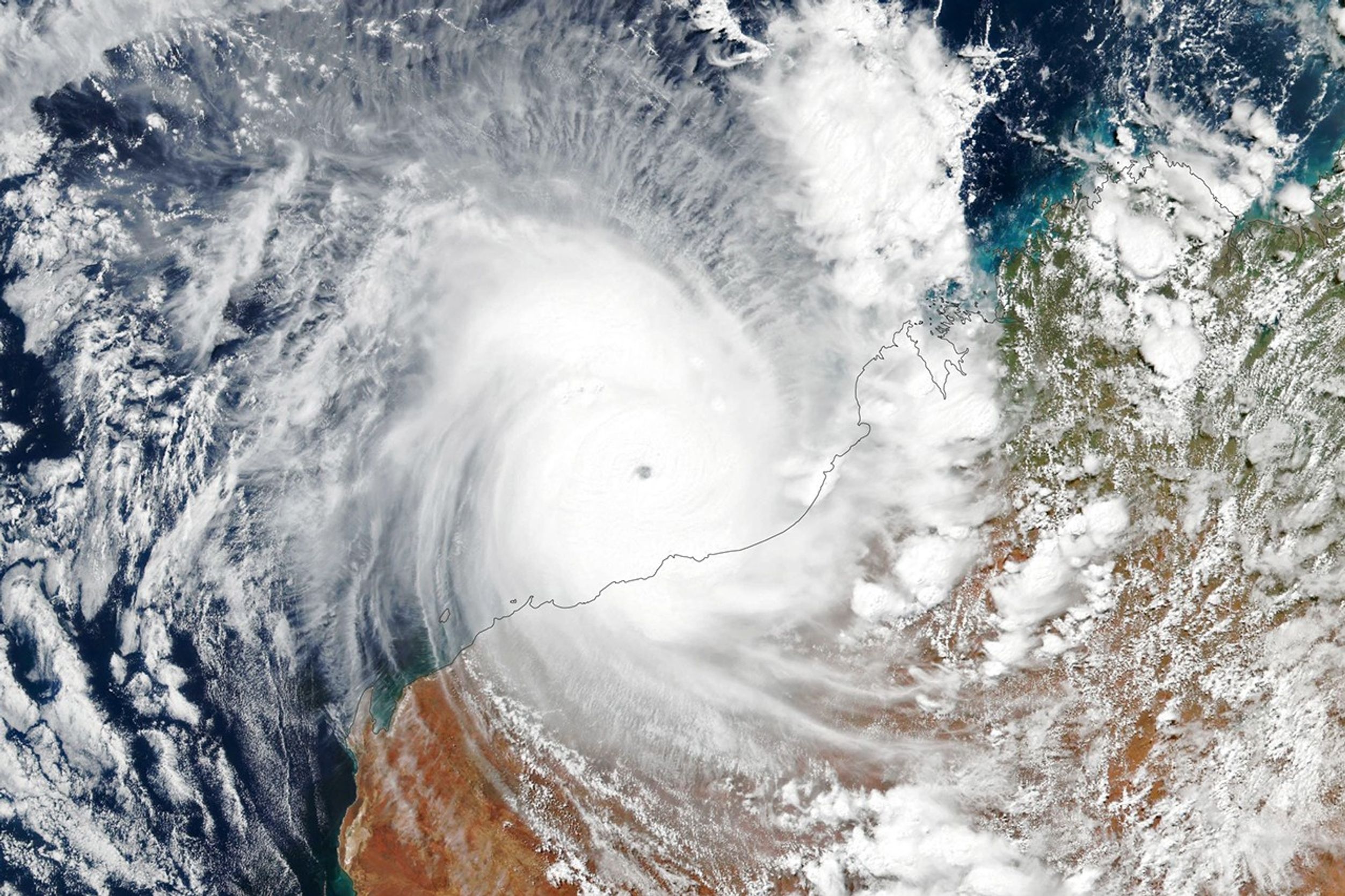
Around midnight local time on April 13, 2023, Tropical Cyclone Ilsa made landfall in Western Australia. Bearing winds that gusted to around 300 kilometers (190 miles) per hour, it was one of the most potent storms to hit the area in recent years.
Earlier that day, the Visible Infrared Imaging Radiometer Suite (VIIRS) sensor on the NASA-NOAA Suomi NPP satellite acquired this image. It shows the storm at 1:45 p.m. local time (05:45 Universal Time) on April 13, 2023.
Around the time of this image, Ilsa was approaching the coast with winds of 240 kilometers (150 miles) per hour. That equates to a category 5 storm on Australia’s intensity scale, which is equivalent to a category 4 storm on the Saffir-Simpson hurricane wind scale. Although the storm’s center had not yet reached the coast, its outer cloud bands were already interacting with land.
Notice that the storm appears to have a relatively small eye. Storms with such small eyes—sometimes called “pinhole” eyes—often spin faster and have more powerful winds. Hurricane Maria, which lashed Puerto Rico in 2017, also had a small eye.
According to Western Australia’s Bureau of Meteorology, winds were especially fierce at Bedout Island (obscured in this image by clouds). Ground-based instruments measured sustained wind speeds of 218 kilometers (135 miles) per hour there—topping the previous record measured of 194 kilometers per hour measured at the island during Cyclone George in 2007.
The storm crossed the coast about 120 kilometers east-northeast of Port Hedland, maintaining category 5 status on the Australian scale. Forecasters called for it to weaken as it moved inland over the Pilbara region and Western Australia’s Northern Interior. This part of Australia has a relatively low population, but communities could still be at risk from destructive winds and heavy rainfall as the storm tracks across the region.
References & Resources
- AP News (2023, April 13) Australia’s most powerful cyclone in 8 years to cross coast. Accessed April 13, 2023.
- Australian Broadcasting Corporation (2023, April 13) Severe Tropical Cyclone Ilsa makes landfall on WA’s Kimberley-Pilbara coast as category five system. Accessed April 13, 2023.
- Australian Broadcasting Corporation (2023, April 13) With Tropical Cyclone Ilsa set to rip through Pilbara at strength, inland communities could face unprecedented risk. Accessed April 13, 2023.
- Australian Bureau of Meteorology (2023, April 13) Tropical Cyclone Technical Bulletin. Accessed April 13, 2023.
- Twitter (2023, April 13) Bureau of Meteorology, Western Australia. Accessed April 13, 2023.
- The Washington Post (2023, April 13) Severe tropical Cyclone Ilsa headed toward landfall in northwest Australia. Accessed April 13, 2023.
NASA Earth Observatory image by Lauren Dauphin, using VIIRS data from NASA EOSDIS LANCE , GIBS/Worldview , and the Suomi National Polar-orbiting Partnership . Story by Kathryn Hansen .