


March 19-April 8, 2023
Burn Scars in Kansas
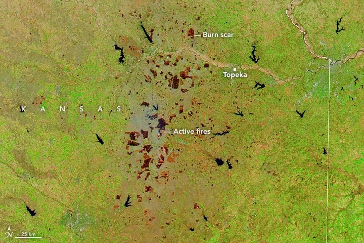
In spring 2023, numerous fires burned across the grassy Flint Hills region of eastern Kansas. Satellite images show fire activity starting to ramp up in late March and early April, which produced a patchwork of burn scars across the region.
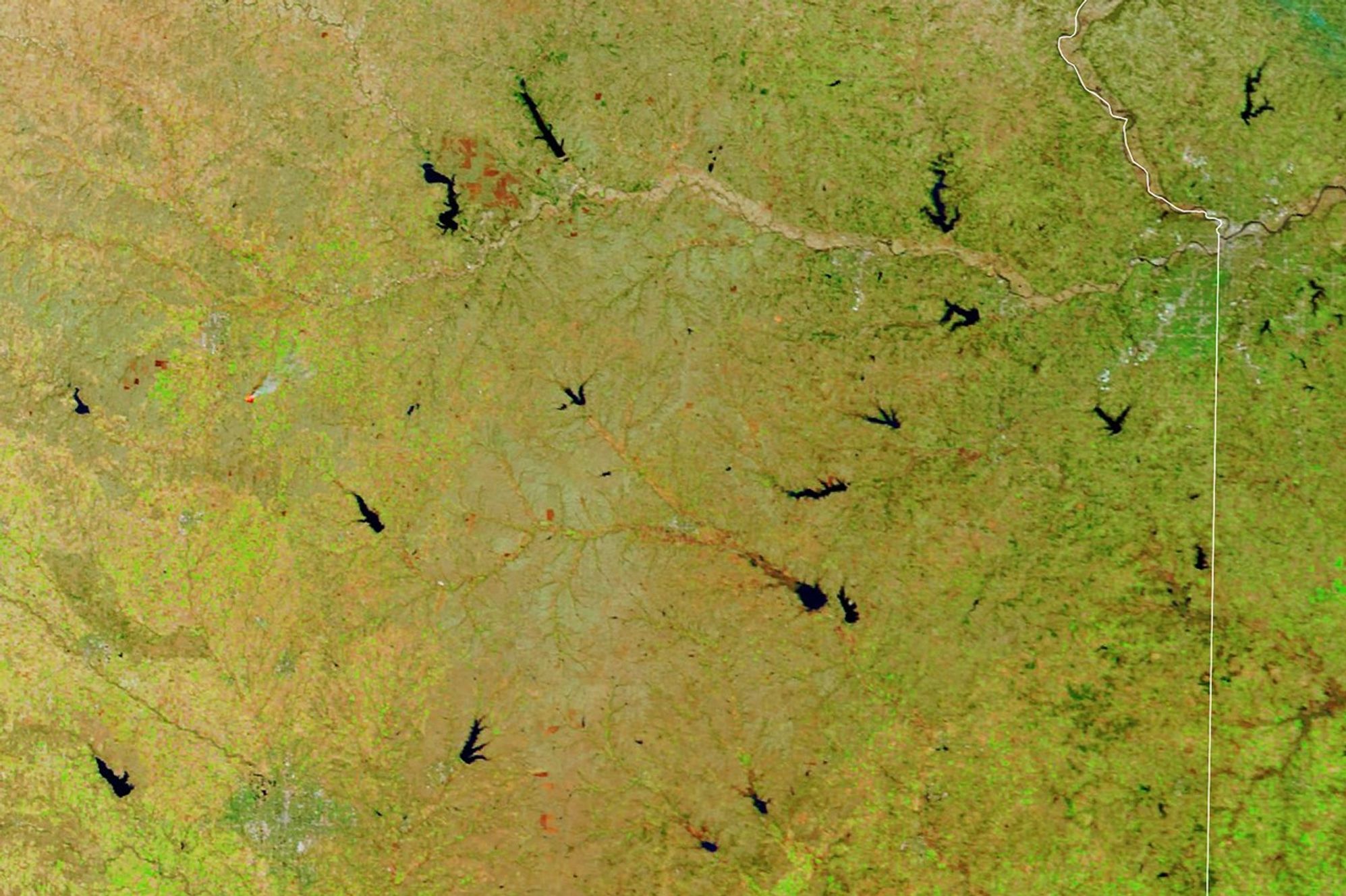
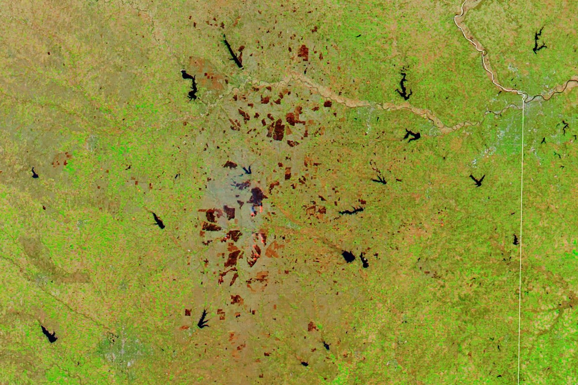
The burn scars are visible in this image (right) acquired on April 8, 2023, with the Moderate Resolution Imaging Spectroradiometer (MODIS) instruments on NASA’s Aqua satellite. The left image, acquired with MODIS on NASA’s Terra satellite, shows the same area on March 19, 2023, prior to the extensive burning.
The false-color images use a combination of visible and infrared light (MODIS bands 7, 2, 1). This view makes it easier to distinguish burn scars (brown) on the landscape. Hotspots associated with active fire fronts are bright red-orange, and vegetation is green.
Kathleen Strabala and Liam Gumley, scientists at the University of Wisconsin-Madison, were looking at satellite images when they noticed the burn scars. “It was unusual to see all of the fire activity in April that was associated with the warm, dry weather in the Midwest last week,” said Gumley, a remote sensing scientist at the Cooperative Institute for Meteorological Satellite Studies, located at the university.
Weather is an important component of the region’s wildland fire season, which peaks each year in March and April. Abundant rainfall during the 2022 growing season produced an above-average amount of grass available to be burned by fires in 2023. On April 4, conditions favorable for wildfires—dry fuels, low humidity, and gusty winds—led the National Weather Service to issue a fire weather watch.
However, it is unclear from satellite imagery alone whether the burn scars are the result of wildland fires or controlled burns. Rangeland burning by ranchers is common this time of year in the tallgrass prairie ecosystem of Flint Hills. Fires remove old vegetation, encourage the growth of fresh grass for forage, and prevent forests from taking over the prairie.
Whichever the source, smoke from the fires can degrade air quality downwind. On April 7, the Kansas Department of Health and Environment issued an air quality advisory for areas north toward Nebraska, as a temperature inversion was expected to trap smoke close to the ground where people live and breathe. The advisory was lifted on April 12.
References & Resources
- Kansas Department of Health and Environment (2023, April 12) Air Quality Advisory Rescinded for Parts of the Flint Hill Region Due to Seasonal Burning. Accessed April 17, 2023.
- KFOR (2023, April 14) Smoke From Controlled Grass Fires In Kansas and Oklahoma Impacting Air Quality in Nebraska. Accessed April 17, 2023.
- K-State Research and Extension News (2023, March 10) Kansas fire season is here, officials say. Accessed April 17, 2023.
- K-State Research and Extension News (2023, February 28) Kansas Fire Season is Here. Accessed April 17, 2023.
- MODIS Images (2023, April 14) Burn Scars across Eastern Kansas. Accessed April 17, 2023.
- NASA Earthdata (2023, April 14) Wildfire detection in the US and Canada within a minute of satellite observation. Accessed April 17, 2023.
- NASA Earthdata (2022, July 20) FIRMS Adds Ultra Real-Time Data from MODIS and VIIRS. Accessed April 17, 2023.
- Space Science and Engineering Center (2022, September 28) One-minute data from UW helps NASA detect wildfires faster. Accessed April 17, 2023.
NASA Earth Observatory images by Lauren Dauphin, using MODIS data from NASA EOSDIS LANCE and GIBS/Worldview . Story by Kathryn Hansen .