


Today’s story is the answer to the October 2023 puzzler.
From above, the 1,000-meter (3,300-foot) deep volcanic pit and soda lake Trou au Natron in northern Chad has the look of a ghostly face staring back at you. An astronaut on the International Space Station captured this photograph of the distinctive feature on February 12, 2023.
The edge of the “face” is partly formed by shadows cast by the rim of a caldera—a type of volcanic crater formed after an explosive eruption or the collapse of the surface into a partially-emptied magma chamber. The “eyes” and “nose” are cinder cones—steep conical hills built around volcanic vents. The cinder cones are thought to be relatively young in geological terms, likely forming within the past few million years and possibly as recently as the past few thousand years.
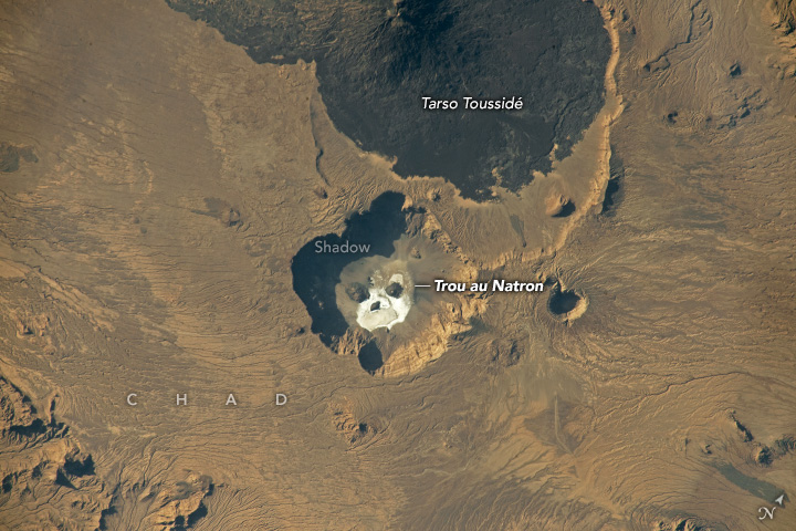
The white area around the “mouth” is a mineral crust made of a salt known as natron—a mixture of sodium carbonate, sodium bicarbonate, sodium chloride, and sodium sulfate. It forms as hot spring water pools on the surface and evaporates, and mineral-rich steam rises from the surface of the geothermally active area.
Trou au Natron lies just southeast of Tarso Toussidé, a broad volcanic feature with fumaroles and an active stratovolcano. One of several volcanic peaks in the Tibesti Mountains, it is the source of several relatively recent—though poorly documented and studied—eruptions.
The remoteness of Trou au Natron makes it difficult for scientists to access. However, analysis of rock and fossil samples collected in the 1960s indicate that Trou au Natron was filled by a glacial lake hundreds of meters deep about 14,000 years ago. An expedition led by German researcher Stefan Kröpelin reached Trou au Natron in 2015 and collected samples of fossilized aquatic algae thought to have formed some 120,000 years ago.
Satellite observations of the region have helped fill in some details. One pair of University of Cambridge researchers have pieced together a rough sequence of the region’s volcanic activity based on observations from the ASTER (Advanced Spaceborne Thermal Emission and Reflection Radiometer) sensor on NASA’s Terra satellite. They divided the activity into six phases, with the formation of Trou au Natron as one of the most recent events of geologic significance.
References & Resources
- Earth Science Picture of the Day (2015, August 24) Tibesti Massif and Trou au Natron Caldera. Accessed October 30, 2023.
- Nature (2015) Exposing Sahara science in the shadow of terrorism. Accessed October 30, 2023.
- NASA Earth Observatory (2022, October 31) Chasing Faces in the Stratosphere. Accessed October 30, 2023.
- New Scientist (2016, July 6) Nomad’s land: Journey into the rugged heart of the Sahara. Accessed October 30, 2023.
- New Scientist (2015, July 10) Volcano hunters dig into the Sahara’s watery past. Accessed October 30, 2023.
- Permenter, J. & Oppenheimer, C. (2007) Volcanoes of the Tibesti massif (Chad, northern Africa). Bulletin of Volcanology, 69, 609-626.
- Soulie-Marsche, I. et al. (2010) Charophytes as bio-indicators for lake level high stand at “Trou au Natron”, Tibesti, Chad, during the Late Pleistocene. Global and Planetary Change, (72) 4, 334-340
Astronaut photograph ISS068-E-53507 was acquired on February 12, 2023, with a Nikon D5 digital camera using a focal length of 500 millimeters. The image was provided by the ISS Crew Earth Observations Facility and the Earth Science and Remote Sensing Unit, Johnson Space Center. The image was taken by a member of the Expedition 68 crew . It has been cropped and enhanced to improve contrast, and lens artifacts have been removed. The International Space Station Program supports the laboratory as part of the ISS National Lab to help astronauts take pictures of Earth that will be of the greatest value to scientists and the public, and to make those images freely available on the Internet. Additional images taken by astronauts and cosmonauts can be viewed at the NASA/JSC Gateway to Astronaut Photography of Earth. Story by Adam Voiland .


