


![Request for Information – Potential [Placeholder for Prize]](https://assets.science.nasa.gov/dynamicimage/assets/science/psd/solar/2023/09/s/solarsystem_0.jpg?w=1024)


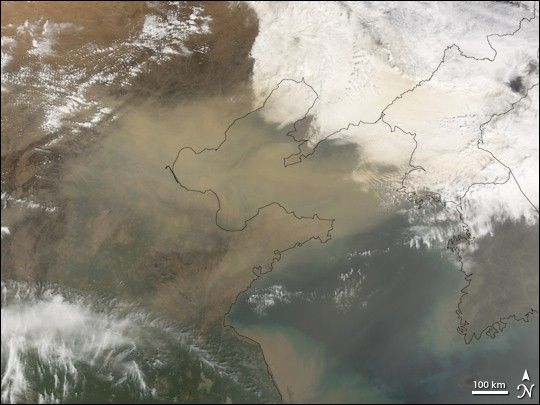
Thick sand from one of China’s famed sandstorms clouded the air over Beijing on April 17, 2006. The storm swept east from the border region between China and Mongolia and blanketed cities across China with gritty yellow sand. The storm was the eighth and worst such storm of 2006, reported the BBC.
The Moderate Resolution Imaging Spectroradiometer (MODIS) flying onboard the Terra satellite took this picture on the morning of April 17. In this image, a thick band of tan dust obscures the view of the land surface below. Immediately east of the sandstorm are thick clouds, colored tan by the airborne dust. Along the coastlines, brownish sediments from both China and the Korean Peninsula cloud the Yellow Sea.
As Terra captured this image, The Korea Times predicted that the storm would strike Korea on the evening of April 17, 2006.
References & Resources
NASA image created by Jesse Allen, Earth Observatory, using data obtained from the Goddard Earth Sciences DAAC.


