















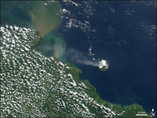
The Manam Volcano emitted a plume of volcanic ash and/or steam on May 23, 2006. The Moderate Resolution Imaging Spectroradiometer (MODIS) flying onboard NASA’s Terra satellite took this picture the same day. In this image, a volcanic plume flows westward away from the island and toward the mainland. Clouds hover over Manam’s summit, a common occurrence over volcanoes. Also visible in this image are two brown-green sediment plumes flowing northward into the ocean from mainland Papua New Guinea.
Lying just 13 kilometers (8 miles) off the coast of mainland Papua New Guinea, the island of Manam is only 10 kilometers (6 miles) wide. It is also one of Papua New Guinea’s most active volcanoes. The volcano is built from layers of hardened lava, ash, and volcanic rocks. The volcano’s summit sports two craters, the southern crater having been the more active in recent history.
References & Resources
NASA image created by Jesse Allen, Earth Observatory, using data provided courtesy of the MODIS Rapid Response team.