


![Request for Information – Potential [Placeholder for Prize]](https://assets.science.nasa.gov/dynamicimage/assets/science/psd/solar/2023/09/s/solarsystem_0.jpg?w=1024)


The seasonal melting of sea ice across the central Arctic Ocean and surrounding basins peaks in July, the region’s warmest month. In Foxe Basin, currents, tidal motion, and winds can stir up the now-fragile pieces of ice, producing art-like patterns on the water’s surface. One such moment of seasonal beauty was on full display on July 15, 2024, when the OLI-2 (Operational Land Imager-2) on Landsat 9 captured this image.
Foxe Basin, off the west coast of Baffin Island in Nunavut, Canada, measures about 400 kilometers (250 miles) across at its widest point. Hudson Bay lies to the south, connected to the basin by Foxe Channel, and additional waterways within the Canadian Arctic Archipelago lie to the west. The image above shows the northeastern part of Foxe Basin and several of its largest islands.
The basin’s waters are often clogged with first-year sea ice—seasonal ice that is less than a year old. New ice begins to form each year around October, according to Environment and Climate Change Canada, and it continues to spread and thicken through the winter until melting begins in late May or early June. As of August 2024, the basin was nearly ice-free, except for areas west of Baffin Island and within Foxe Channel.
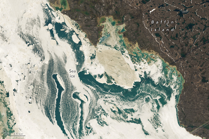

The images above show detailed views of patterns in the ice on July 15. The basin’s ice is often in motion, producing the wispy tendrils of ice and paths of open water that trail some of the larger pieces.
All of this motion also helps stir up sediment, which is the main reason for the ice’s muddy appearance. Pieces of eroded soil and debris—sloughed from the surrounding land and stirred up from the shallow seafloor—mix with the seawater and stain the ice brown. Algae, which can grow under the ice and wash onto its surface, might also be contributing to the discoloration.
The basin is a haven for an array of wildlife. Several polynas—areas of open water within the sea ice—are an important gathering place for species such as bowhead whales and polar bears. Walrus, migrating birds, and other creatures also rely on the basin’s resources.
References & Resources
- Canadian Wildlife Service Polynyas in the Canadian Arctic. Accessed August 2, 2024.
- Environment and Climate Change Canada (2024, July) Seasonal Summary North American Arctic Waters: Spring 2024. Accessed August 2, 2024.
- Environment and Climate Change Canada (2015) Where sea ice is found. Accessed August 2, 2024.
- The European Space Agency (2008, August 1) Earth from Space: Foxe Basin. Accessed August 2, 2024.
- NASA Earth Observatory (2018, September 24) Dirty Ice in Foxe Basin. Accessed August 2, 2024.
NASA Earth Observatory images by Wanmei Liang , using Landsat data from the U.S. Geological Survey . Story by Kathryn Hansen.


