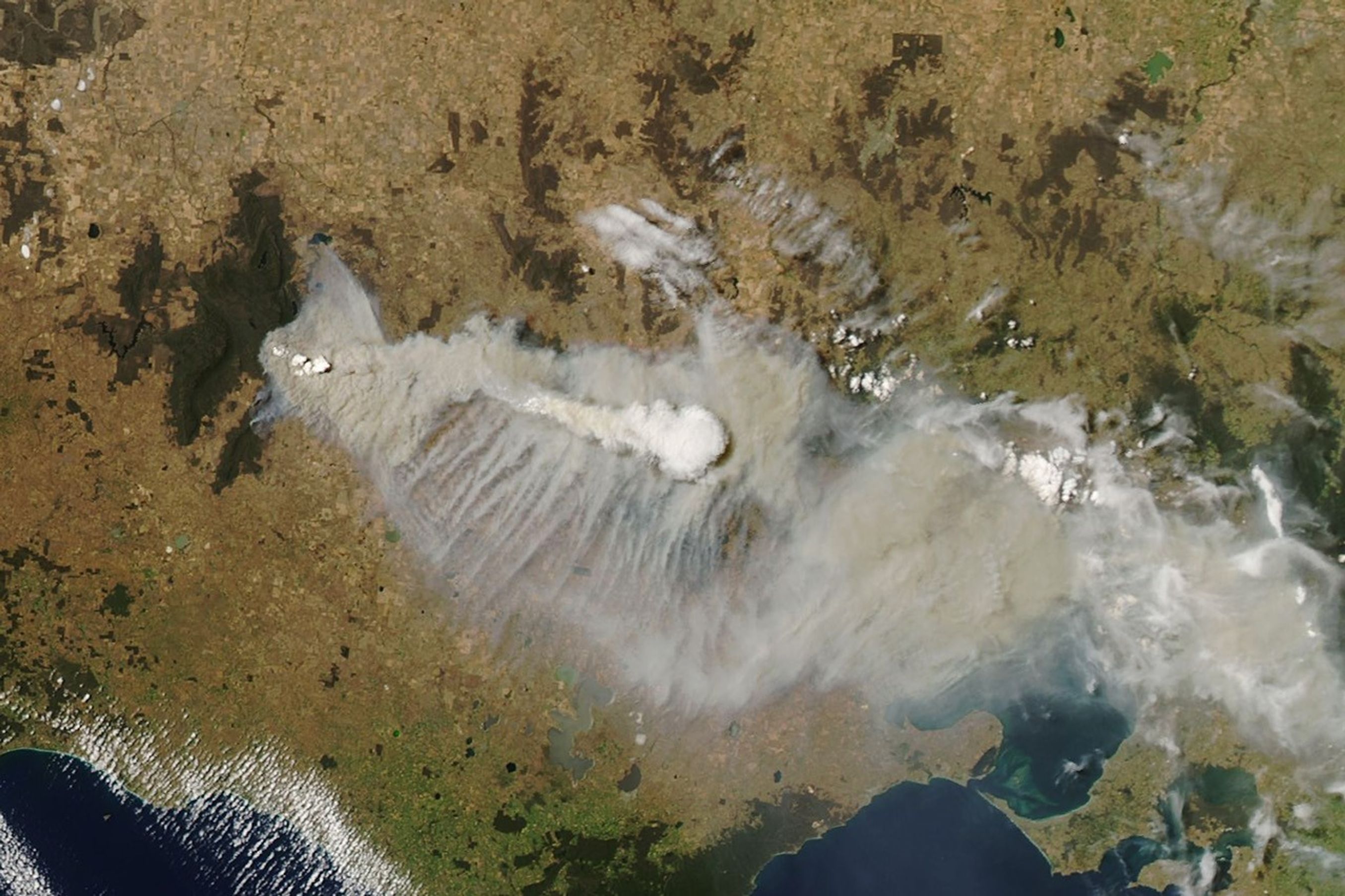


Hot, dry conditions and gusty winds fueled several bushfires in southeastern Australia. The MODIS (Moderate Resolution Imaging Spectroradiometer) on NASA’s Aqua satellite captured this image of smoke streaming from the region’s largest fire as it burned through parts of Grampians National Park in Victoria on December 20, 2024.
Ignited by lightning on December 16, the fire pushed north along the Wannon River toward the communities of Halls Gap, Bellfield, Lake Fyans, and Pomonal. Victoria officials urged residents of these communities to evacuate. Smoke from the fire also blanketed Melbourne, the capital and most populous city in Victoria. As of December 20, the fire had charred more than 120 square kilometers (46 square miles) of land, according to news reports.
A pyrocumulus cloud—also called flammagenitus—is visible above the smoke in the Aqua image. These tall clouds often appear in satellite imagery as opaque white patches hovering over darker smoke. Pyrocumulus clouds are similar to cumulus clouds, but the heat that produces updrafts comes from fire instead of the Sun heating the ground. As pyrocumulus clouds rise, water vapor cools and condenses and can produce rains and full-fledged thunderstorms, making them pyrocumulonimbus clouds (pyroCbs).
For scientists to classify a cloud as pyrocumulus or pyrocumulonimbus, cloud top temperatures observed by satellites must be minus 40 degrees Celsius (-40 degrees Fahrenheit) or cooler. According to U.S. Naval Research Laboratory meteorologist Michael Fromm, MODIS detected cloud tops with temperatures of -51°C at 05:30 Universal Time (4:30 p.m. local time) when Aqua acquired the image. This was the first pyroCb of the Southern Hemisphere summer that researchers have detected, according to Fromm.
A team of NASA-funded scientists working with the Injected Smoke and Pyrocumulonimbus Experiment (INSPYRE) has begun a multi-year effort to investigate which fires produce pyrocumulus clouds, what mechanisms cause them to inject smoke all the way into the stratosphere, and whether smoke transported by pyroCbs affects Earth’s radiation budget.
References & Resources
- The Age (2024, December 21) Smoke blankets Melbourne as regional fires threaten homes. Accessed December 20, 2024.
- Bureau of Meteorology, via X (2024, December 19) Fire Weather Warning. Accessed December 20, 2024
- NASA INSPYRE. Accessed December 20, 2024.
- Fromm, M., et al. (2010) The Untold Story of Pyrocumulonimbus. Bulletin of the American Meteorological Society, (91)9, 1193-1210.
- Otago Daily Times (2024, December 20) ’Take shelter’: Twin bushfires rage in Victoria. Accessed December 20, 2024.
- U.S. Naval Research Laboratory (2024, May 9) NRL Selected to Lead Critical Science Mission on Wildfires and Smoke. Accessed December 20, 2024.
- Victoria (2024) Incidents & Warnings. Accessed December 20, 2024.
NASA Earth Observatory image by Wanmei Liang , using MODIS data from NASA EOSDIS LANCE and GIBS/Worldview . Story by Adam Voiland .