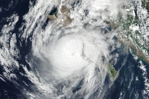















August 22, 2005
Hurricane Hilary is shown here as observed by the Moderate Resolution Imaging Spectroradiometer (MODIS) on NASA’s Aqua satellite at 1:45 p.m. local time, on August 22, 2005. Located off the coast of northern Mexico in the Pacific Ocean, the hurricane has been gathering strength and organizing into a classic spiral structure for several days. It appears here at its peak strength, with sustained winds of around 150 kilometers per hour (90 miles per hour). It is gradually moving east-northeast. The system will slowly lose strength over the next several days, and it is not expected to make landfall at any time.
References & Resources
NASA image created by Jesse Allen, Earth Observatory, using data obtained from the MODIS Rapid Response team.