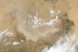
















Dust plumes blew through central Iraq and over the Persian Gulf in mid-June 2008. The Moderate Resolution Imaging Spectroradiometer (MODIS) on NASA’s Terra satellite captured this image on June 16, 2008. This natural-color image shows dust plumes blowing toward the southeast, but unlike a larger storm on June 8, 2008, the plumes are relatively small and distinct from each other, separated by areas of clear sky.
Like the Iraq dust storm earlier in the month, these plumes result from a shamal. A shamal is a northwesterly wind that often blows over the floodplain of the Tigris and Euphrates Rivers, whose fine sediments provide substantial material for dust storms in the region.
References & Resources
- References
- University Corporation for Atmospheric Research. Forecasting Dust Storms. Accessed June 9, 2008.
NASA image courtesy of Jeff Schmaltz, MODIS Rapid Response Team , NASA-Goddard Space Flight Center. Caption by Michon Scott.