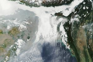
Winter haze is a regular visitor in northern India. The haze piles up along the Himalaya Mountains, forming a strip of white-gray that obscures the ground. The Moderate Resolution Imaging Spectroradiometer (MODIS) on NASA’s Aqua satellite captured this true-color image on December 2, 2009. A line of bright white clouds crosses over uniform gray haze, hinting that the haze is close to the ground.
Wintertime temperature inversions contribute to the build up of haze. Inversions occur when cold air gets trapped under a layer of warm air. Usually, air high in the atmosphere is cooler than air near Earth’s surface. Warmer air near the surface rises, allowing pollutants from the surface to disperse in the atmosphere. During the winter, cold air often moves down the Himalaya Mountains, settling over northern India’s Ganges Plain. This layer of cold air gets trapped beneath a layer of warmer air. Since the cold air cannot rise above the warm air, pollution builds in the cold air as long as the temperature inversion lasts. The haze seen in early December 2009 may well be the result of a temperature inversion.
References & Resources
NASA Earth Observatory image created by Jesse Allen, using data provided courtesy of the MODIS Rapid Response team. Caption by Holli Riebeek.


