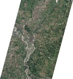



















The Missouri River spilled over its banks around Glasgow, Missouri, in late June 2010. The Advanced Land Imager (ALI) on NASA’s Earth Observing-1 (EO-1) satellite captured this natural-color image on June 19, 2010.
West of the town of Glasgow, the Missouri River curves toward the south-southwest and then toward the northeast. Immediately west of town, the river takes a sharp turn toward the south. In the bend in the river before its northeastern turn, flooding is apparent. Muddy brown water has collected north of the river, along Epperson Island. More floodwater appears south and west of the river where it curves toward the south-southwest. Additional flooding appears along riverbanks upstream.
Patches of off-white on the water surface result from sunglint. Away from the river and the town, the land in this area appears primarily as a patchwork of brown and green croplands interspersed with patches of trees.
According to the National Weather Service Advanced Hydrologic Prediction Service, the Missouri River’s water level was projected to drop below the major flood stage after June 21. The water level remained well above normal, however, and flood warnings continued for Glasgow and other communities along the Missouri River.
References & Resources
- Advanced Hydrologic Prediction Service. (2010, June 21). Missouri River at Glasgow. Accessed June 21, 2010.
- Cronkleton, R.A. (2010, June 21). Flood warnings continue for cities along the Missouri River. Kansas City Star. Accessed June 22, 2010.
NASA Earth Observatory image created by Robert Simmon, using EO-1 ALI data provided courtesy of the NASA EO-1 team. Caption by Michon Scott.